Lagos has always been a water city. It sits on a low-lying coastal plain stitched together by the Atlantic Ocean, barrier islands, creeks, and the Lagos Lagoon. That geography powers trade, culture, and growth—and it also makes flooding unavoidable. The real question for the next decades is not “How do we stop floods?” but “How do we shape the city so floods are smaller, slower, safer, and less damaging?”
That shift—from fighting water to designing with it—is where landscape architecture becomes a frontline climate strategy.
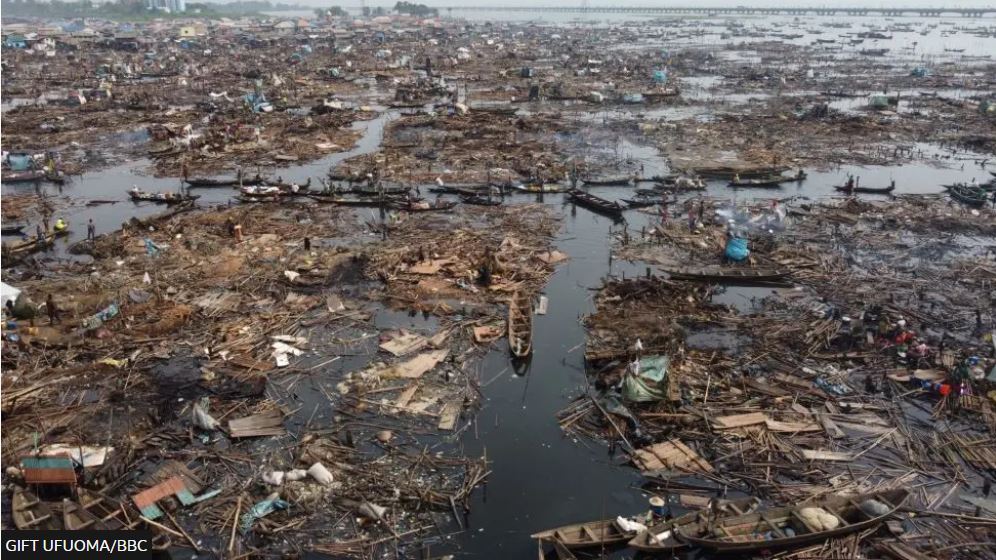
Makoko, Lagos, Nigeria (Source: Gift Ufuoma_BBC)
Why Lagos’ flood risk is rising
Flooding in Lagos isn’t one thing. It’s usually compound flooding: intense rain overwhelms drains, lagoon levels rise with tides, and storm surge can push ocean water inland—sometimes all at once. Briefings on Lagos flood risk describe exposure to coastal flooding from tidal effects and ocean incursion into low-lying areas during storms, with sea-level rise and mangrove loss likely worsening impacts.
Two extra accelerants matter for design:
- Land subsidence (the ground sinking) can make “today’s safe elevation” become “tomorrow’s floodplain.” Research using satellite/geodetic observations flags subsidence as a meaningful risk in parts of Lagos.
- Coastline reshaping and dredging can undermine natural buffers, shift sediment, and increase erosion—reducing the coast’s ability to absorb wave energy. Recent reporting describes how extensive dredging and land-making around Lagos can carry environmental costs that include reduced flood resilience.
So adaptation has to work at two speeds:
- daily nuisance flooding from rain and tides, and
- rare-but-devastating storm surges.
The design mindset: landscapes as flood infrastructure
Traditional flood control often treats landscape as leftover space and pipes/walls as the “real” system. Climate adaptation flips that: parks, streets, wetlands, and waterfronts become the system.
A useful way to frame it is a layered “hydro-urban” approach:
- Slow water where it falls (capture at source)
- Store water temporarily (designed flood spaces)
- Convey water safely (blue-green corridors, canals, overflow streets)
- Protect the coast (hybrid edges that break waves and manage surge)
- Recover quickly (materials, planting, and programs that rebound after inundation)
This is not just theory—cities with delta/lagoon geographies have been testing it for years.
1) Protect the edge: hybrid coastal defences for storm surge
Lagos needs coastal protection, but “just build a wall” is rarely enough. Walls reflect wave energy, can worsen erosion downstream, and fail catastrophically if overtopped. The most robust coastal strategies are hybrid: they combine engineered structures with nature-based wave attenuation.
Nature-based buffers that also look like a city
- Mangroves and wetlands: Mangroves can attenuate waves and reduce overtopping pressure on seawalls, allowing lower or slimmer hard structures in some contexts.
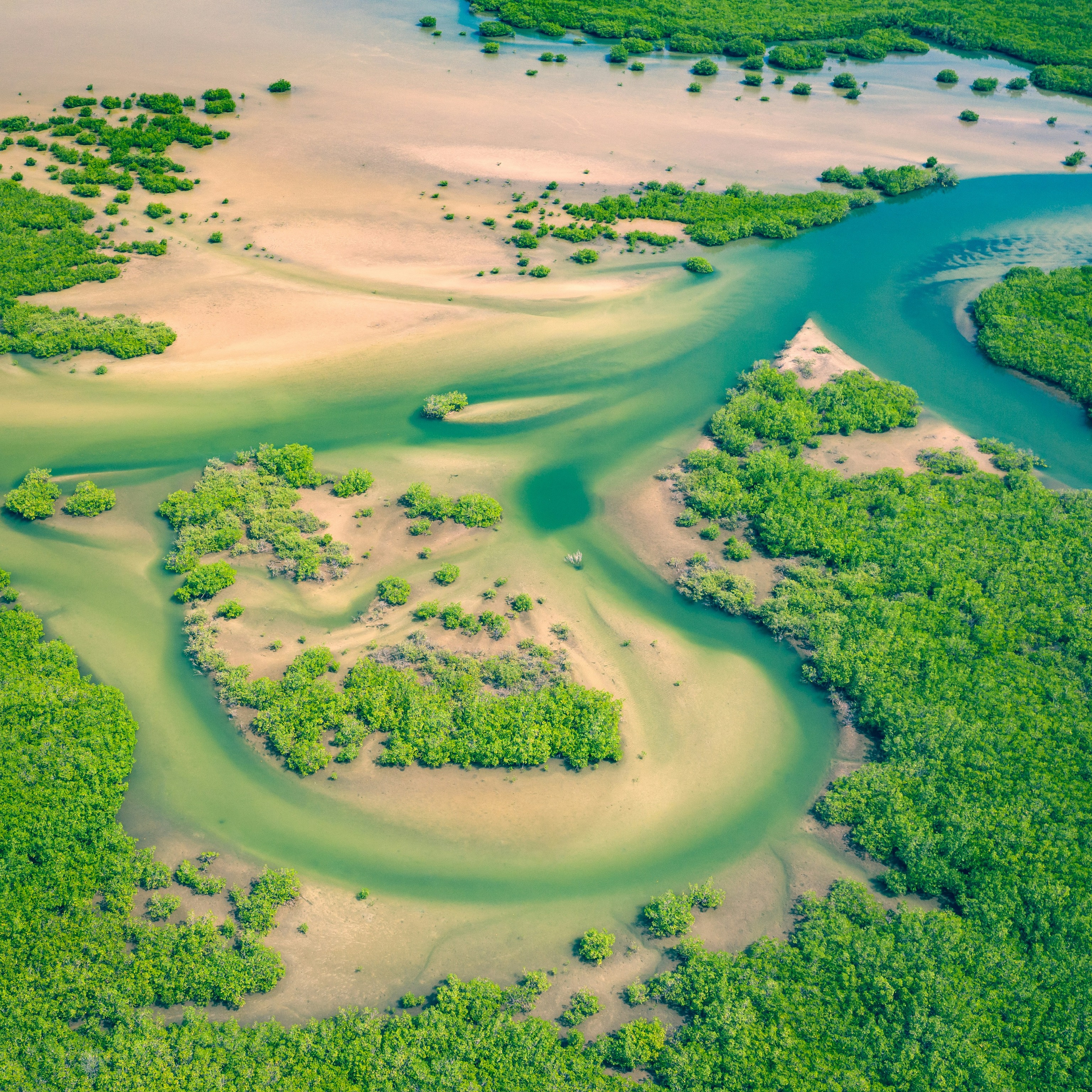
Mangroves (Source: curioso-photography-OOiygaquXZs-unsplash)
Lagos move: protect and expand mangrove belts along lagoon edges and creeks; pair restoration with boardwalks, fishing access, and community stewardship so it’s not “fenced-off nature.”
- Living shorelines, reefs, and breakwaters: New York’s “Living Breakwaters” uses offshore structures designed to reduce wave energy while improving habitat.
Lagos move: explore reef-like breakwaters and “living revetments” along exposed stretches (especially where sand and dredging have changed wave dynamics), with local ecology as a design constraint—not an afterthought.
Strategic hard infrastructure (but multifunctional)
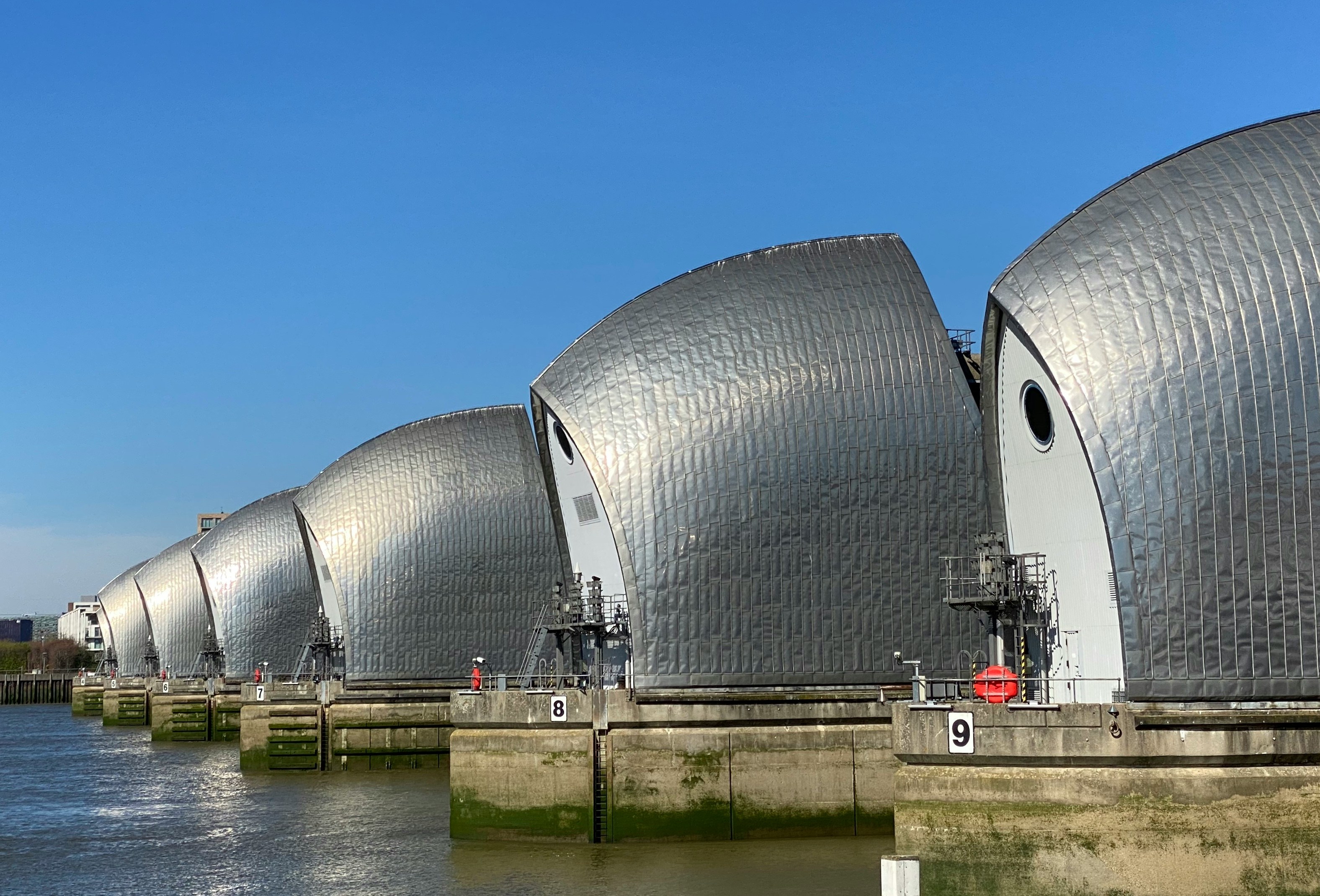
London's Thames Barrier (Source: john-cameron-lmYIAQb6q1w-unsplash)
Venice’s MOSE system uses mobile gates at lagoon inlets to reduce extreme high-tide flooding.
Lagos move: don’t copy-paste megaprojects—but do evaluate whether critical inlets/harbour channels need future surge- control options, combined with evacuation and “exceedance” planning.
- Reclaimed-land seawalls as public realm: Engineering project writeups for Lagos’ coastal reclamation emphasize seawall/revetment design that doubles as an amenity and coastal protection.
Lagos move: if hard edges are built, insist they become civic infrastructure (walkways, shade, fishing terraces, maintenance access) and that they’re tested for how they affect erosion next door.
Key landscape point: the coastline should be treated as a gradient, not a line—reef/mangrove/terrace/dune → promenade → elevated safe routes → adaptable building zones.
2) Make room inland: “floodable” public space that works every day
Storm surge is dramatic, but Lagos also needs to manage high-intensity rainfall and runoff. The most effective design pattern here is designed flooding: put water where you want it to go.
Floodable parks and “water squares”
Rotterdam’s Benthemplein Water Square is a classic example: public space most days, stormwater storage when it pours.
Copenhagen’s Cloudburst approach uses streets, parks, and canals as surface routes and reservoirs for extreme rain events.
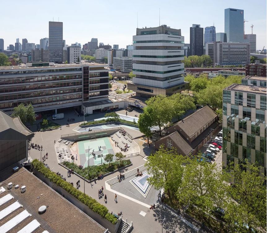
The water square Benthemplein holds a twofold strategy: it is public space and storm water storage combined in one space. (Source: urbanisten.nl_Ossip van Duivenbode)
Lagos moves (street-scale to district-scale):
- Convert selected parks, school fields, and market plazas into dual-use retention basins (safe edges, durable materials, quick drain-down).
- Design “blue streets”: certain corridors become controlled overflow routes during cloudbursts, using raised curbs, planted swales, and protected crossings.
Treat rain at the source
Singapore’s ABC Waters program institutionalizes things landscape architects already love: rain gardens, vegetated swales, and bioretention systems with clear design guidance.
ABC Waters, Singapore (Source: lepl.com.sg)
Lagos moves:
- Require new developments (especially on Lekki/Victoria Island) to meet runoff reduction targets using rain gardens, green roofs, permeable paving, and cisterns.
- Build neighbourhood “micro-retention” everywhere: small interventions replicated thousands of times.
A practical Lagos argument for this hybrid approach: some policy commentary suggests green + grey systems can reduce flooding while also reducing the overall cost burden compared with relying only on conventional grey expansion.
3) Shape the urban form: elevate, adapt, and design for exceedance
Even with great landscapes, water will sometimes arrive. Cities that live with water design their buildings and streets so flooding is non-catastrophic.
Elevate what must not fail
Hamburg’s HafenCity builds with an elevated “plinth” strategy and flood protection integrated into the district’s topography and public realm.
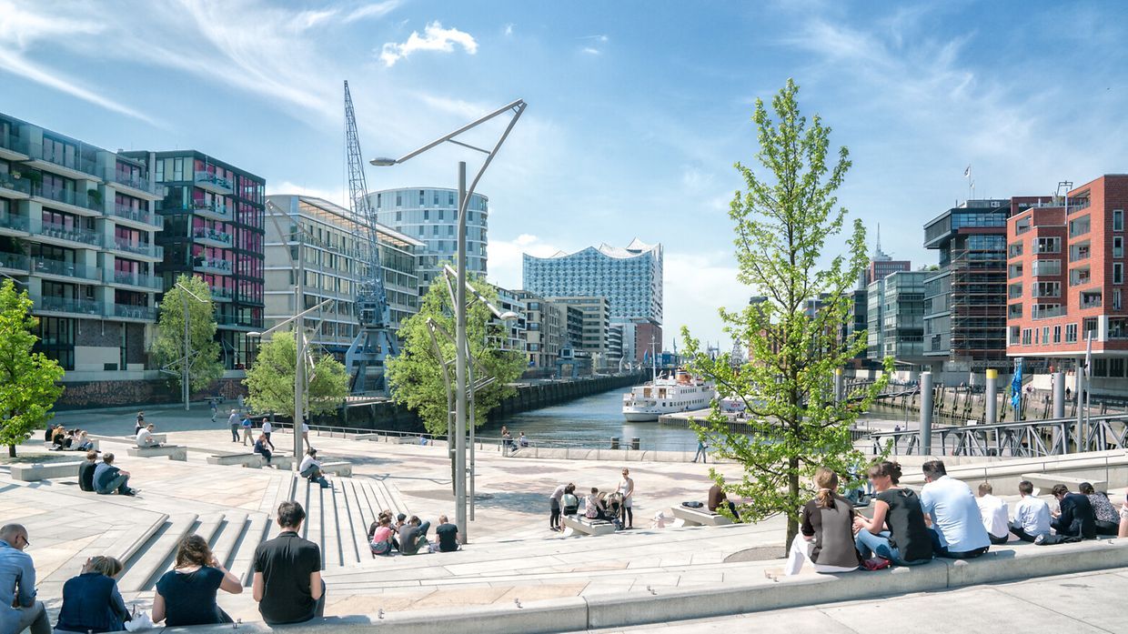
HafenCity neighbourhood, Hamburg, Germany (Source: hamburg.com_Mediaserver Hamburg / Andreas Vallbracht)
Lagos move: require critical infrastructure (power, telecoms, hospitals, pumping, key roads) to meet higher elevation and redundancy standards, especially in low-lying districts.
Floodable ground floors, sacrificial layers
Use ground floors as flexible, cleanable, or non-critical space (parking, storage, workshops), with living areas above. This is old wisdom in water cities—refined with modern materials, detailing, and code.
Beware maladaptation
Miami Beach has used pumps and raised roads as part of its response to sea-level rise—effective in some locations, but not without controversy and distributional effects.
Lagos move: avoid “protect the rich, flood the rest” outcomes by testing street-raising, seawalls, and drainage changes for who gets wetter as a side effect.
4) Maintenance is design: sediment, drains, and the politics of everyday water
Landscape architecture fails when it ignores operations.
Lagos agencies publicly list ongoing stormwater drainage projects (construction and dredging of channels). But drainage is only as good as:
- routine clearing,
- solid waste management,
- enforcement against blocking waterways,
- and community trust that systems work for them.
Early warning also matters. A C40-related document on an extreme water events early warning initiative describes Lagos’ flood challenges as linked to rapid urbanization and drainage constraints, and argues for data-driven, community-based approaches.
5) Equity is not optional: the waterfront is also home
Coastal “resilience” can become a pretext for displacement if it’s not designed with communities. Recent reporting on demolitions in Makoko highlights how waterfront interventions can collide with housing rights and livelihoods.
A Lagos resilience agenda should include in-situ upgrading options where possible:
- safer stilt systems,
- elevated walkways,
- sanitation that works with tides,
- community evacuation hubs,
- and shoreline buffers that protect residents and ecosystems.
A Lagos-specific synthesis: what an integrated project portfolio could look like
Instead of a single mega-solution, think in connected layers:
- Coastal “surge parks” and hybrid shorelines on exposed ocean edges (dunes/reefs/terraces + targeted hard structures)
- Lagoon mangrove restoration + public access (boardwalks, fishing nodes, habitat corridors)
- A network of floodable open spaces (parks, plazas, schoolyards) linked to canals
- Blue streets and sponge districts where runoff is slowed, stored, and filtered locally
- Elevated safe routes for emergency movement and daily mobility during floods
- Upgraded informal waterfront neighbourhoods as pilot “living with water” districts
- Operations + early warning as permanent budget lines, not temporary campaigns
The IPCC notes that low-lying coastal cities like Lagos are among places where coastal defences will need to be built or upgraded as sea levels rise—making design choices today long-lived and consequential.
The big idea: turn flood protection into a better city
The best flood-resilient landscapes don’t look like fear. They look like:
- parks that become reservoirs,
- waterfronts that are biodiverse and walkable,
- streets that stay passable longer,
- and communities that aren’t sacrificed to protect investment.
Lagos can get there by treating climate adaptation as a city-making project—where every berm is a promenade, every retention basin is a playground, and every restored mangrove edge is both protection and identity.
