1. West Africa Coastal Areas Resilience Investment Project (WACA ResIP)
Location: Coastal zones of Benin, Côte d’Ivoire, Mauritania, São Tomé and Príncipe, Senegal, Togo, The Gambia, Ghana, and Guinea-Bissau
Lead Agency: World Bank Group
Type: Regional Coastal Resilience Program / Climate Adaptation / Ecosystem Restoration
Website:wacaprogram.org
Overview
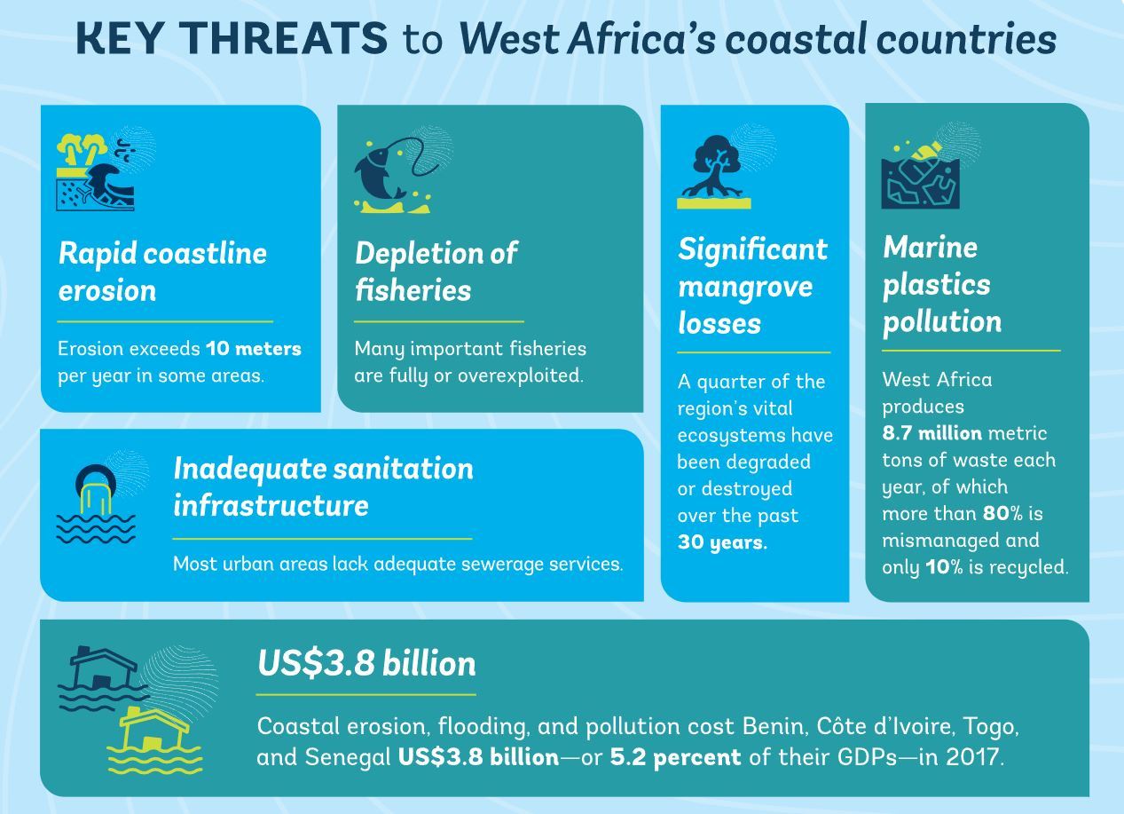
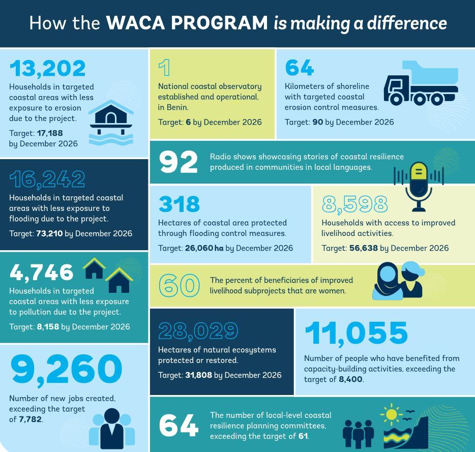
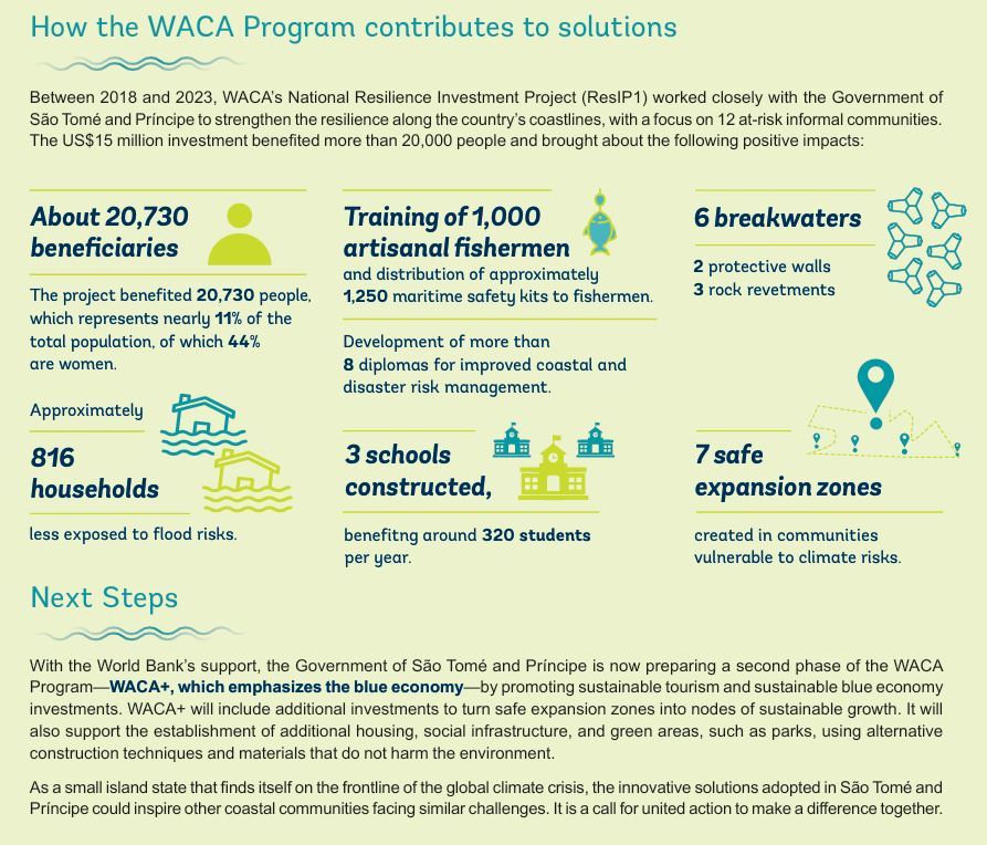
The West Africa Coastal Areas Resilience Investment Project (WACA ResIP) is a regional initiative aimed at strengthening the resilience of coastal communities and ecosystems in West Africa. Launched in 2018, the project addresses the increasing threats of coastal erosion, flooding, pollution, and climate change impacts that endanger livelihoods, infrastructure, and biodiversity along the West African coast. WACA ResIP fosters regional collaboration, integrates climate risks into national policies, and implements both physical and social investments to enhance coastal resilience.
Eco-Features
-
Nature-Based Solutions: Implementation of mangrove restoration, dune stabilization, and wetland rehabilitation to protect shorelines and restore ecosystems.
-
Integrated Coastal Management: Development of national and regional strategies that incorporate climate risk assessments and sustainable land-use planning.
-
Pollution Control: Initiatives to manage solid waste and reduce water pollution in coastal areas.
-
Early Warning Systems: Establishment and strengthening of systems to monitor and respond to coastal hazards.
Ocean Conservation and Community Resilience Initiatives
-
Livelihood Support: Promotion of income-generating activities such as sustainable fishing, aquaculture, and ecotourism to diversify and strengthen local economies.
-
Community Engagement: Active involvement of local populations in planning and implementing resilience measures, ensuring culturally appropriate and sustainable interventions.
-
Regional Collaboration: Facilitation of knowledge exchange and joint action among participating countries to address transboundary coastal challenges.
-
Capacity Building: Training and support for local institutions to enhance their ability to manage coastal resources and respond to climate risks.
Key Achievements
-
Financial Mobilization: Secured over $450 million in funding from various sources, including the World Bank, Global Environment Facility, Nordic Development Fund, and others.
-
Policy Integration: Mainstreamed climate resilience into national coastal management plans and policies across participating countries.
-
Infrastructure Development: Constructed protective structures and restored natural barriers to mitigate coastal erosion and flooding.
-
Community Impact: Enhanced the resilience of numerous coastal communities, improving livelihoods and reducing vulnerability to climate-related hazards.
Role of Landscape Architecture
While not led by a traditional landscape architecture firm, WACA ResIP embodies principles central to the discipline, such as ecological restoration, sustainable land-use planning, and community-centred design. The project's emphasis on integrating natural systems with human development aligns with landscape architecture's holistic approach to creating resilient and adaptive environments.
Learn More / References
-
WACA Program Official Website: wacaprogram.org
-
World Bank Project Details: projects.worldbank.org
-
Climate Policy Initiative Case Study: climatepolicyinitiative.org
-
Nordic Development Fund Project Page: ndf.int
2. INACCT Resilience Project – Designing Inclusive African Coastal Cities’ Resilience
Source: africa.iclei.org
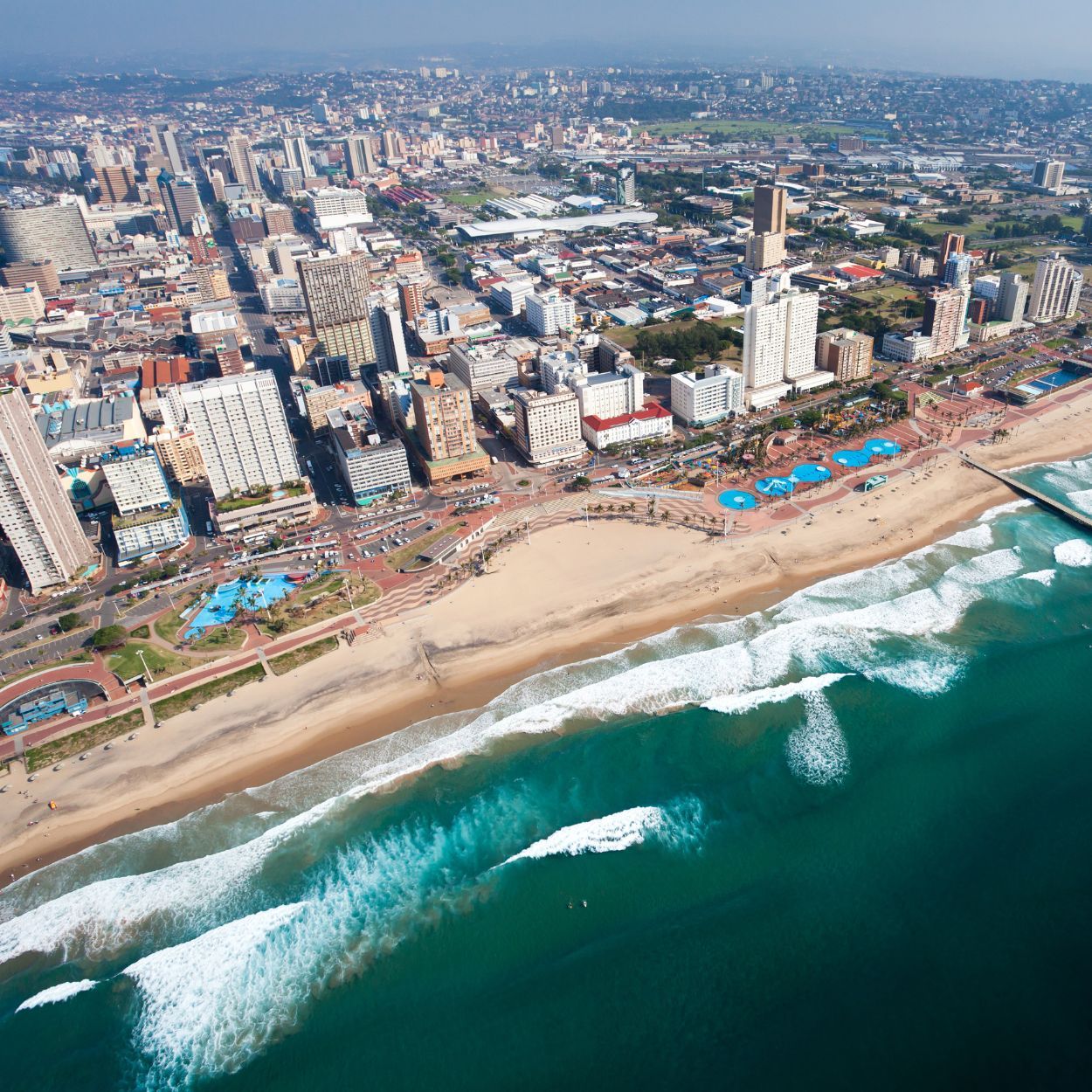
Location: Beira, Mozambique & eThekwini (Durban), South Africa
Lead Organizations: ICLEI Africa, Eduardo Mondlane University (UEM), University of KwaZulu-Natal (UKZN)
Type: Urban Resilience Research / Climate Adaptation / Community Co-Design
Website: https://africa.iclei.org/project/inacct/
Overview
The INACCT Resilience Project (Designing Inclusive African Coastal Cities’ Resilience) is a transdisciplinary initiative aimed at strengthening urban resilience planning in African coastal cities, with a focus on inclusivity and proactive adaptation. Funded by the Climate Adaptation and Resilience (CLARE) initiative—a UK-Canada partnership—the project centers on Beira, Mozambique, and eThekwini (Durban), South Africa, both of which have recently experienced devastating climate-induced flooding events.
INACCT emphasizes co-learning and co-design processes, integrating diverse knowledge systems and prioritizing the voices of marginalized communities, including women, children, and people with disabilities. Through participatory methodologies, the project seeks to develop context-specific, gender-responsive frameworks for climate resilience that can be adapted and applied across the African continent.
Eco-Features
-
Risk-Informed Planning: Development of co-created risk and resilience profiles for informal settlements, incorporating local knowledge and scientific data to inform urban planning.
-
Nature-Based Solutions: Exploration of ecosystem-based approaches to mitigate flooding and enhance urban green spaces, contributing to both ecological health and community well-being.
-
Early Warning Systems: Assessment and promotion of community-led forecast and early warning systems to improve disaster preparedness and response.
-
Sustainable Infrastructure: Recommendations for integrating resilient infrastructure that accommodates the needs of vulnerable populations in informal settlements.
Ocean Conservation and Community Resilience Initiatives
-
Inclusive Engagement: Active involvement of marginalized groups in resilience planning, ensuring that adaptation strategies address the specific vulnerabilities and capacities of diverse community members.
-
Knowledge Exchange: Facilitation of learning labs and workshops that bring together stakeholders from different sectors and backgrounds to share experiences and co-develop solutions.
-
Policy Integration: Collaboration with municipal authorities to embed inclusive resilience strategies into local governance frameworks and urban development plans.
-
Regional Dissemination: Creation of a Gender-Responsive Coastal Cities Resilience Planning Framework to guide other African cities in adopting inclusive adaptation practices.
Key Achievements
-
Community-Centred Research: Implementation of participatory methods such as photovoice and storytelling to capture the lived experiences of residents in informal settlements.
-
Capacity Building: Strengthening of local institutions and stakeholders' abilities to plan and implement inclusive resilience measures.
-
Policy Influence: Contribution to the development of municipal policies that prioritize equitable adaptation and disaster risk reduction.
-
Scalable Frameworks: Development of adaptable tools and guidelines that can inform resilience planning in other coastal cities facing similar challenges.
Role of Landscape Architecture
While not led by a traditional landscape architecture firm, the INACCT Resilience Project embodies principles central to the discipline, such as ecological restoration, sustainable land-use planning, and community-centred design. The project's emphasis on integrating natural systems with human development aligns with landscape architecture's holistic approach to creating resilient and adaptive environments.
By focusing on the interplay between urban form, ecological processes, and social dynamics, the project highlights the importance of designing spaces that are both environmentally sustainable and socially inclusive. This approach underscores the potential for landscape architecture to contribute meaningfully to climate adaptation and resilience in rapidly urbanizing contexts.
Learn More / References
-
ICLEI Africa – INACCT Resilience Project: https://africa.iclei.org/project/inacct/
-
CLARE Programme Overview: https://clareprogramme.org/project/designing-inclusive-african-coastal-cities-resilience-inacct-resilience/
-
IDRC Project Details: https://idrc-crdi.ca/en/what-we-do/projects-we-support/project/designing-inclusive-african-coastal-cities-resilience-i
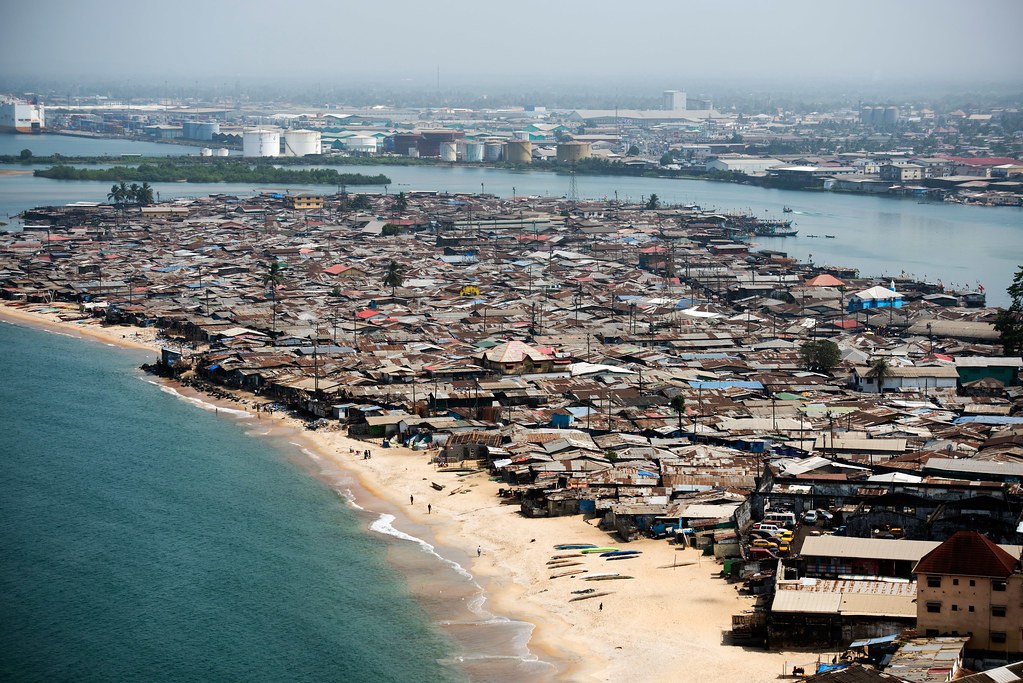
3. Makoko Floating School – NLÉ Architects
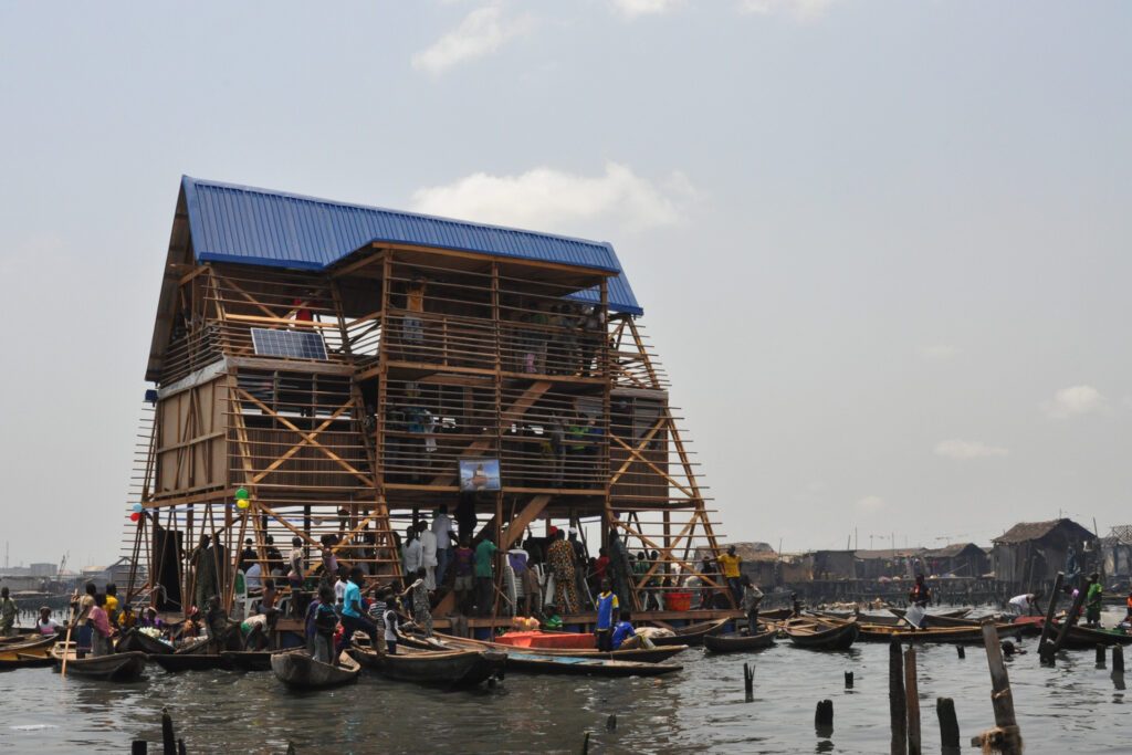
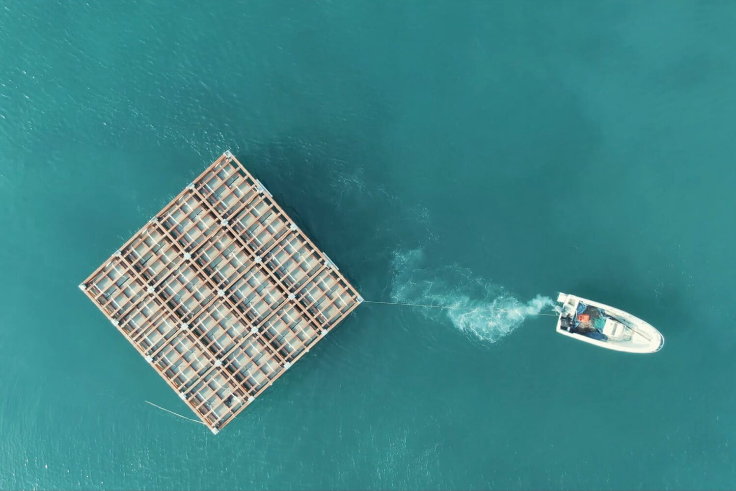
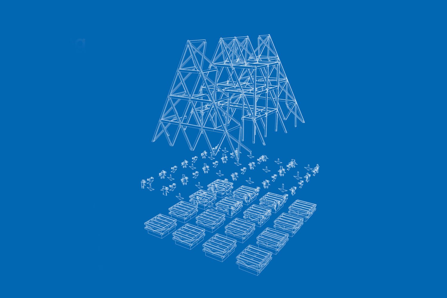
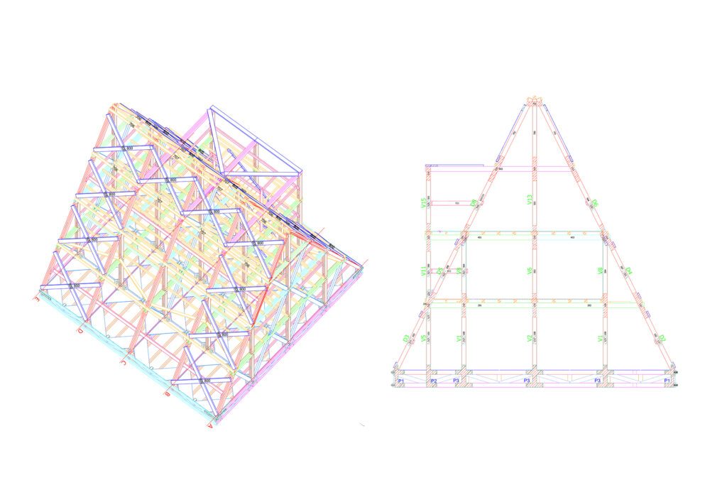
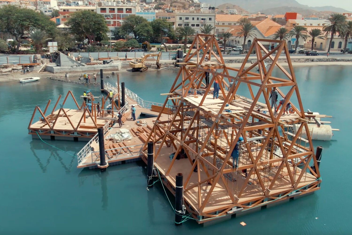
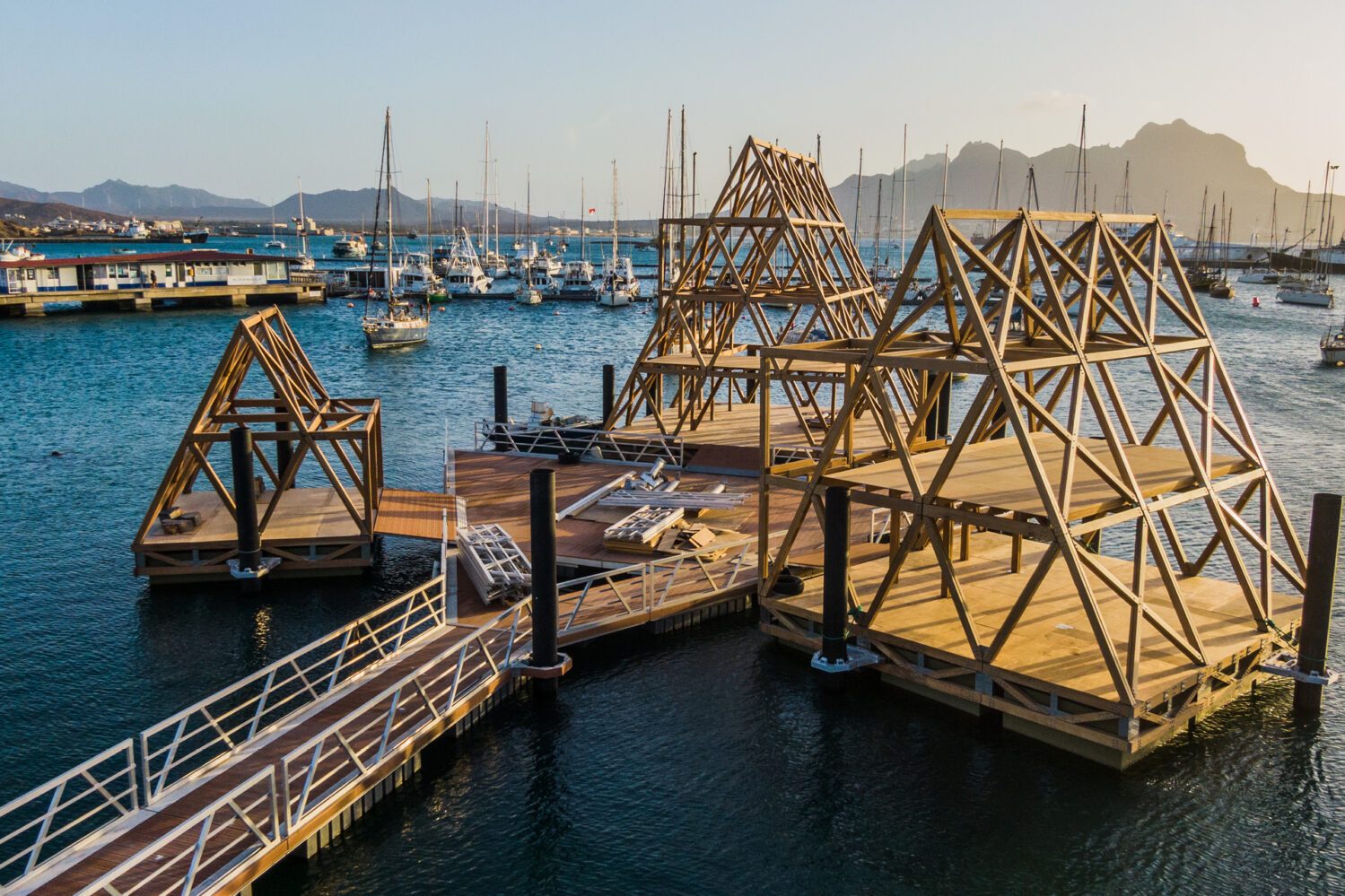
Makoko Floating System – MFS™ – is a simple way to build on water by hand. It is a prefabricated, modular, floating A-frame, sustainable timber structure that can be locally produced, assembled and disassembled, quickly and manually for developments on water, in advanced or developing regions around the world. - Source: nlestudios.com
Source: nlestudios.com
Location: Makoko, Lagos Lagoon, Nigeria
Firm: NLÉ Architects (Founder: Kunlé Adeyemi)
Type: Floating Architecture / Community Infrastructure / Prototype for Climate Resilience
Website: https://nleworks.com
Overview
The Makoko Floating School was a groundbreaking prototype developed by NLÉ Architects in collaboration with the Makoko community in Lagos, Nigeria. Makoko is an informal, water-bound settlement often described as the "Venice of Africa," home to thousands living in stilt houses above the Lagos Lagoon. With rising sea levels and inadequate infrastructure, the area faced severe risks from flooding and climate change.
The project was conceived as a climate-adaptive educational space that would serve both as a school and a community gathering area, floating on the water rather than being anchored to unstable land. Designed by Kunlé Adeyemi and his team, the school became an icon of innovative, low-cost, sustainable architecture that addressed local needs while sparking global conversations on climate-responsive design in vulnerable urban communities.
Eco-Features
-
Amphibious Architecture: Designed to float on a base of reused plastic barrels, allowing it to rise and fall with the water level.
-
Locally Sourced Timber: The building was constructed primarily from locally available wood, minimizing cost and reducing transportation emissions.
-
Passive Cooling & Natural Ventilation: An open-triangle form with perforated walls and shading systems enabled airflow and daylight, eliminating the need for mechanical cooling.
-
Low Energy Footprint: The structure used no electricity-dependent systems, relying on sustainable design to regulate temperature and light.
-
Minimal Environmental Disruption: As a floating structure, it avoided disrupting aquatic ecosystems and preserved traditional water-based lifestyles.
Ocean Conservation and Community Resilience Initiatives
-
Flood Resilience: The floating design responded directly to flooding risks, providing a replicable model for architecture in flood-prone regions.
-
Community Engagement: The school was co-created with local residents and carpenters, ensuring cultural relevance and knowledge transfer.
-
Education Access: Addressed a critical gap in educational infrastructure for children in marginalized waterfront communities.
-
Prototype for Other Settlements: The success of the Makoko model led to iterations like MFS II, presented at the Venice Biennale, and inspired discussions about floating infrastructure for other vulnerable coastal and island areas.
-
Awareness Raising: By attracting global attention, the project helped put informal settlements and climate justice on the international design agenda.
Key Achievements
-
Global Recognition: Received the 2016 Silver Lion at the Venice Biennale and was featured in major exhibitions and journals globally.
-
Replicable Design: Inspired other amphibious and floating design projects around the world, particularly in areas affected by sea level rise.
-
Education and Advocacy: Showcased how design can empower communities, not just aesthetically but politically and socially.
-
Integration with Traditional Practices: Adapted to existing ways of life in Makoko, reinforcing cultural practices while improving quality of life.
Role of Landscape Architecture
While primarily an architectural project, Makoko Floating School aligns closely with landscape architectural principles by working at the interface of water, community, and ecology. The school was embedded within the landscape of the lagoon, responding to its seasonal rhythms and local ecological conditions.
It also presented a new urban typology for wetland zones, prompting landscape architects to explore adaptive landscapes that can float, move, or otherwise respond dynamically to changing environmental conditions. Its broader influence supports resilience thinking, climate adaptation, and ecological literacy—all key themes in landscape architecture today.
Learn More / References
-
NLÉ Architects: https://nleworks.com/case/makoko-floating-school
-
Kunlé Adeyemi – TED Talk on Makoko: https://www.ted.com/talks/kunle_adeyemi
-
Venice Biennale 2016 – Reporting from the Front: https://www.labiennale.org/en/architecture/2016
-
UN-Habitat: Floating Cities for a Changing Climate – https://unhabitat.org
-
Guardian article: Makoko Floating School: a beacon of hope for the world's urban poor – https://www.theguardian.com/cities/2016
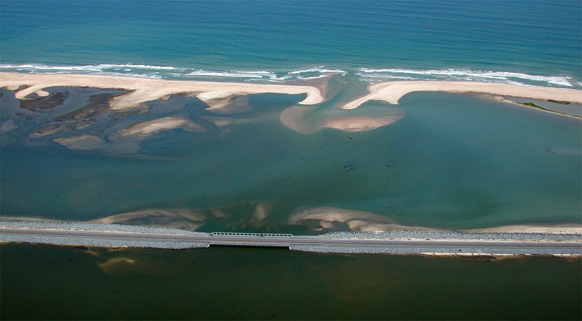
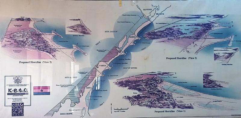
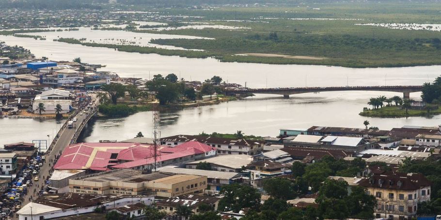
4. Keta Sea Defence Project – Ghana’s Coastal Protection Initiative
Source: baird.com
Source: semanticscholar.org
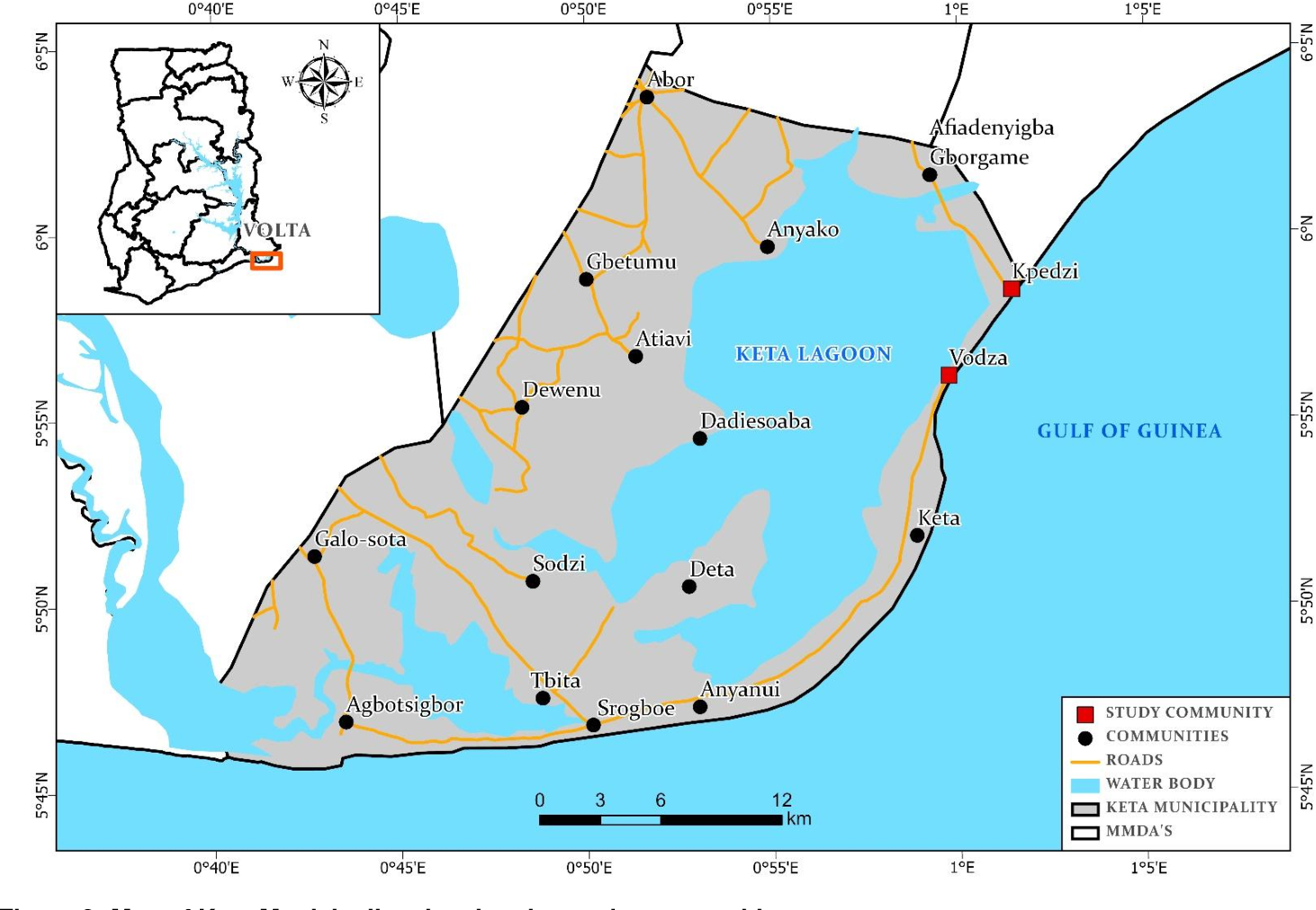
Location: Keta Municipality, Volta Region, Ghana
Firm/Authority: Ghana Ministry of Works and Housing (with international contractors including China Harbour Engineering Company Ltd.)
Type: Coastal Infrastructure / Sea Defence / Shoreline Protection
Website: https://www.mwh.gov.gh
Overview
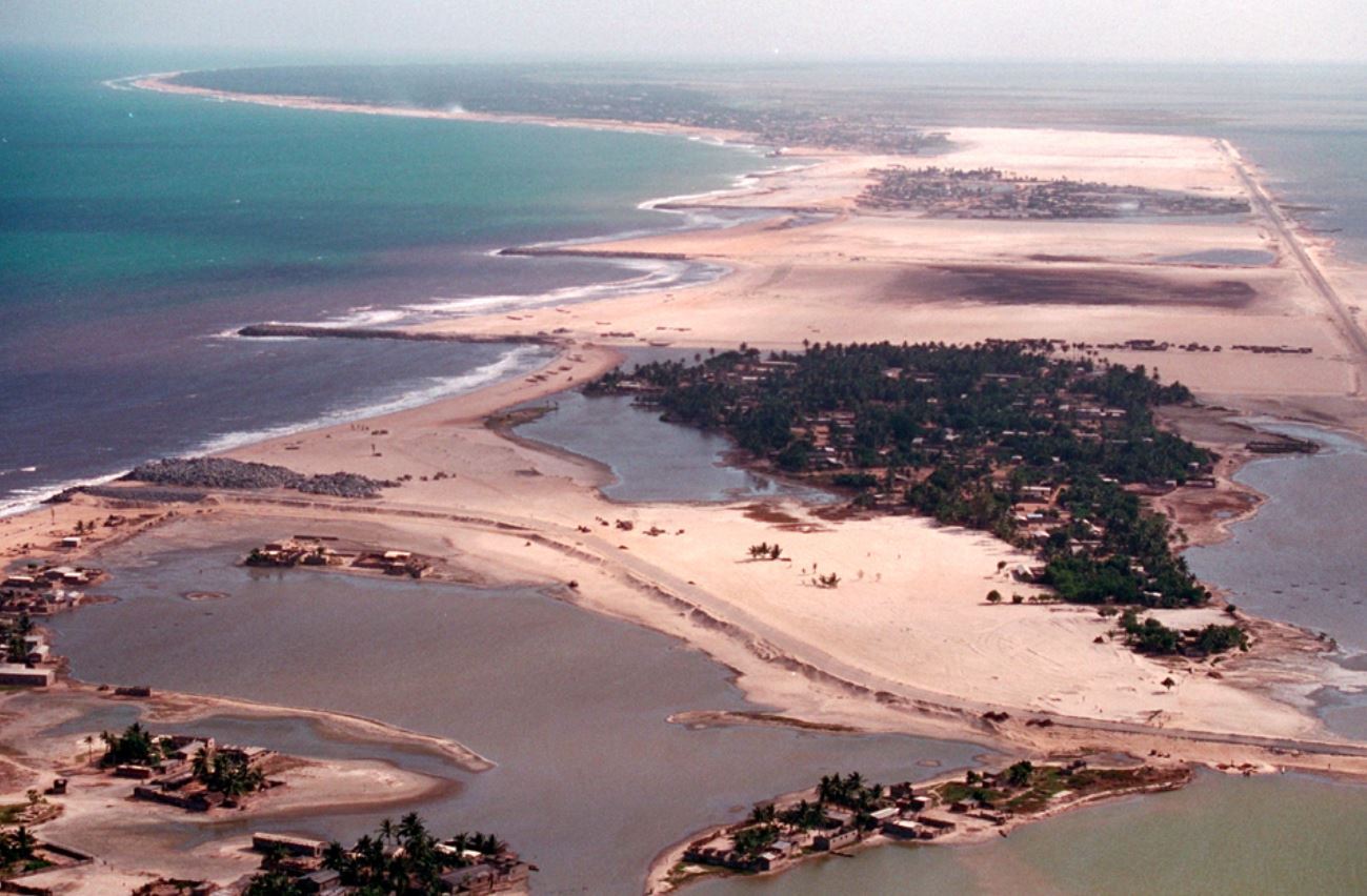
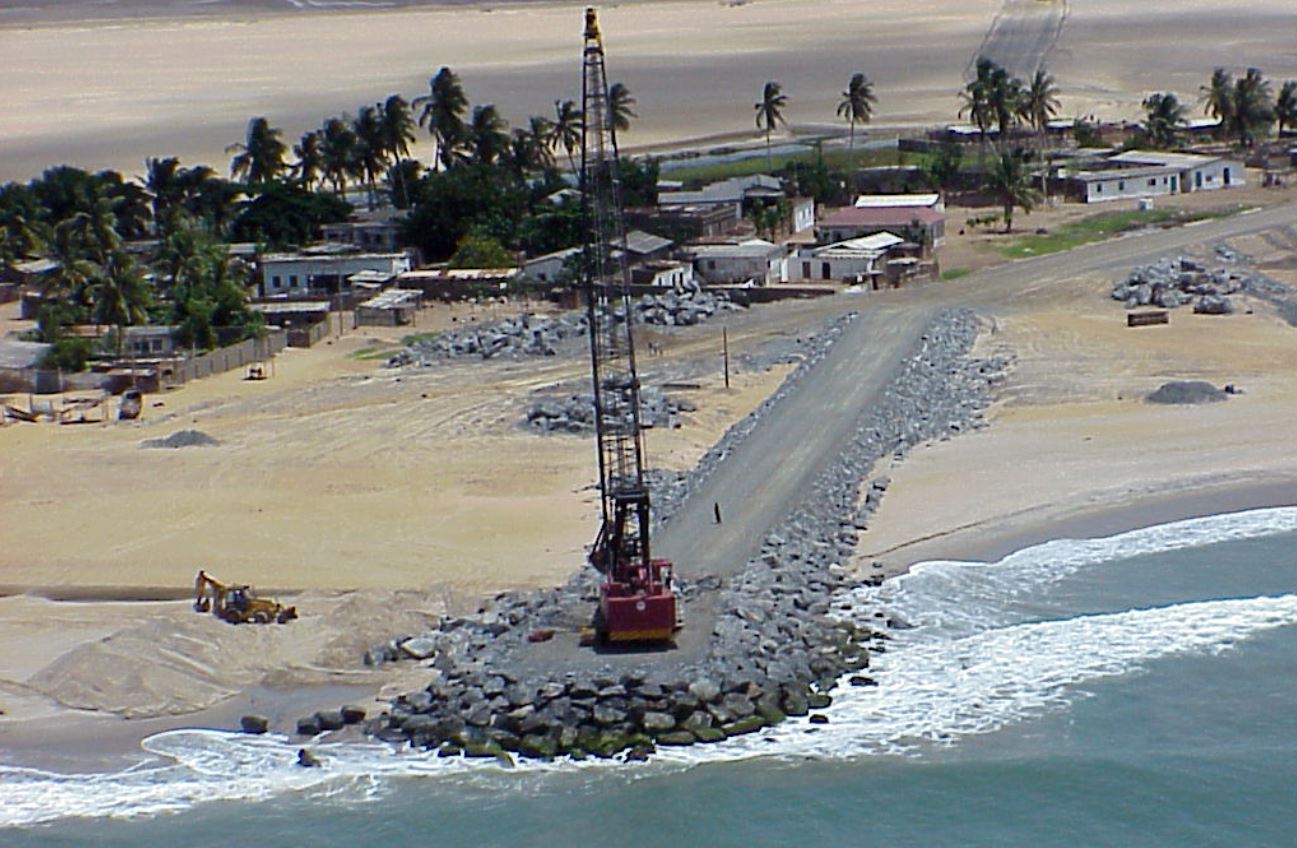
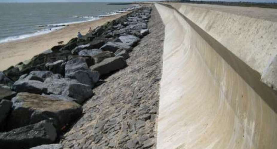
The Keta Sea Defence Project is a large-scale coastal engineering effort launched by the Government of Ghana to address severe coastal erosion, tidal flooding, and habitat loss in the Volta Region, particularly in and around the towns of Keta, Kedzi, and Hlorve. Stretching along the eastern Ghanaian coast, this area has historically suffered from the encroachment of the sea, with entire villages having been submerged or rendered uninhabitable over the decades.
The project began in phases in the early 2000s and is considered one of the most extensive and strategically important coastal protection efforts in West Africa. It is not only an infrastructural response to climate threats but also a foundation for livelihood security, social protection, and local economic revitalization.
Source: modernghana.com
Source: baird.com
Source: baird.com
Source: modernghana.com
Eco-Features
-
Rock Revetments and Groynes: These structures break wave energy and stabilize the coastline, reducing erosion and protecting inland settlements.
-
Beach Nourishment: Replenishment of eroded beaches with sand to restore natural coastal buffers.
-
Mangrove Reforestation (in adjacent areas): NGOs and local actors have initiated pilot mangrove restoration efforts along the protected zones to support natural coastal defences.
-
Drainage Improvements: Installation of stormwater channels and culverts to reduce flood risk during storm surges.
Ocean Conservation and Community Resilience Initiatives
-
Protection of Local Habitats: By controlling erosion, the project has helped preserve remaining wetlands and lagoons, critical for migratory birds and marine life such as crabs and shellfish.
-
Livelihood Protection: The project secures fishing communities from tidal incursions, enabling residents to sustain traditional livelihoods such as artisanal fishing and salt harvesting in the Keta Lagoon area.
-
School and Infrastructure Preservation: Several schools, roads, and health facilities that were at risk of being destroyed by the sea have been saved or restored post-construction.
-
Disaster Mitigation: The region, previously devastated by recurrent floods, has seen improved climate resilience, allowing more stable housing and food production.
Key Achievements
-
Stabilization of Over 8km of Shoreline: The project has dramatically reduced the rate of erosion in some of the most vulnerable coastal stretches in Ghana.
-
Reclamation of Eroded Land: Coastal reclamation has provided new ground for community housing and economic activities.
-
Improved Safety and Livelihoods: More than 30,000 people now benefit from reduced flood risk, leading to improved health, security, and access to education.
-
Increased Government and Global Attention: The Keta initiative has been cited by regional climate resilience programs as a model for coastal adaptation.
Role of Landscape Architecture and Urban Planning
While engineered by civil infrastructure professionals, the Keta Sea Defence Project presents opportunities for integration with landscape architecture and ecological urban planning:
-
Green Infrastructure Synergies: Post-construction, designers and planners can introduce buffer zones with mangroves, rain gardens, and coastal parks to enhance biodiversity and support recreation.
-
Public Space and Tourism Revitalization: Shoreline protection enables the safe development of boardwalks, markets, and visitor areas, opening up sustainable tourism opportunities.
-
Resilient Urban Design: Urban planners can now safely promote adaptive housing, early-warning systems, and spatial zoning that respects coastal dynamics.
Future planning should aim to link hard infrastructure with soft ecological systems, using approaches aligned with the Global Covenant of Mayors for Climate and Energy or ICLEI’s Resilient Cities strategies.
Learn More / References
-
Ghana Ministry of Works and Housing: https://www.mwh.gov.gh
-
United Nations Development Programme (UNDP) Ghana: https://www.gh.undp.org
-
News Ghana: https://newsghana.com.gh
-
GhanaWeb Article – Keta Sea Defence Project and Coastal Erosion
-
Boateng, I. (2009). Development of Integrated Shoreline Management Planning: A Case Study of Keta Coastal Zone, Ghana. Journal of Coastal Conservation.
5. Building Urban Climate Resilience in Southeastern Africa
Location: Morondava (Madagascar), Zomba (Malawi), Chókwè (Mozambique), Moroni (Comoros)
Lead Organizations: UN-Habitat, Oxfam, DiMSUR (Disaster Risk Management, Sustainability and Urban Resilience Technical Centre)
Type: Integrated Urban Climate Adaptation / Resilience Infrastructure / Community-Based Planning
Website: https://www.oxfamitalia.org/sea-project/
Overview
The Building Urban Climate Resilience in Southeastern Africa project is a four-year, $14 million initiative (2020–2024) funded by the Adaptation Fund. It aims to enhance climate resilience in four vulnerable coastal and riverine cities: Morondava, Zomba, Chókwè, and Moroni. These cities face escalating risks from cyclones, flooding, sea-level rise, and inadequate infrastructure.
The project adopts a multi-tiered approach, combining regional knowledge exchange, national policy strengthening, and local participatory planning. It integrates physical infrastructure upgrades with community-led adaptation strategies, focusing on inclusivity and long-term sustainability.
Eco-Features
-
Nature-Based Solutions: Implementation of mangrove reforestation, wetland rehabilitation, and green buffers to mitigate flooding and coastal erosion.
-
Sustainable Drainage Systems: Construction of improved drainage channels and flood-proof infrastructure to manage stormwater effectively.
-
Elevated Infrastructure: Development of flood-resilient roads, bridges, and safe havens to ensure accessibility during extreme weather events.
-
Solid Waste Management: Enhancement of waste collection and disposal systems to prevent blockages and reduce health hazards.
Ocean Conservation and Community Resilience Initiatives
-
Community Engagement: Active involvement of local populations in planning and decision-making processes to ensure culturally appropriate solutions.
-
Capacity Building: Training programs for local authorities and communities on disaster risk reduction and climate adaptation strategies.
-
Regional Collaboration: Facilitation of knowledge exchange among the four cities to share best practices and lessons learned.
-
Policy Integration: Support for the development of national and local policies that incorporate climate resilience into urban planning.
Key Achievements
-
Pilot Initiatives: Implementation of 23 priority projects across the four cities, including infrastructure upgrades and ecosystem restoration efforts.
-
Tool and Guideline Development: Creation of resources to guide sustainable urban planning and climate adaptation at the national level.
-
Enhanced Institutional Frameworks: Strengthening of governmental capacities to manage and sustain resilience initiatives.
-
Improved Livelihoods: Reduction in vulnerability and enhancement of economic opportunities for communities through resilient infrastructure and ecosystems.
Role of Landscape Architecture
While not led by traditional landscape architecture firms, the project embodies core principles of the discipline, such as ecological restoration, sustainable land-use planning, and community-centred design. By integrating natural systems with urban development, the project demonstrates how landscape architecture can contribute to climate adaptation and resilience in rapidly urbanizing contexts.
Learn More / References
-
Adaptation Fund Project Page: https://www.adaptation-fund.org/building-urban-climate-resilience-in-southeastern-africa/
-
UN-Habitat News Release: https://unhabitat.org/news/13-jul-2020/un-habitat-launches-climate-resilience-project-in-south-eastern-africa
-
Oxfam Italia Project Overview: https://www.oxfamitalia.org/sea-project/
6. Sibaya Coastal Precinct – Devmco Group & Tongaat Hulett Developments
Location: eMdloti, KwaZulu-Natal, South Africa
Lead Developers: Devmco Group & Tongaat Hulett Developments
Type: Mixed-Use Coastal Development / Eco-Urbanism / Resilient Masterplan
Website: https://sibayaprecinct.co.za/
Overview
The Sibaya Coastal Precinct is a visionary 1,000-hectare master-planned development situated along South Africa’s North Coast. Launched in 2016, it is strategically located between uMhlanga and Ballito, adjacent to King Shaka International Airport. Designed to harmonize urban living with environmental stewardship, the precinct integrates residential, commercial, and recreational spaces while preserving significant natural landscapes.
The development is organized into seven distinct nodes, each offering a unique blend of amenities and living options. With a commitment to sustainability, 60% of the land is dedicated to green spaces, including a 350-hectare protected coastal forest. The precinct aims to set a benchmark for future-focused, eco-conscious urban development in Africa.
Eco-Features
-
Protected Coastal Forest: A 350-hectare indigenous dune forest is conserved within the precinct, serving as a natural buffer against coastal erosion and providing habitat for diverse flora and fauna.
-
Green Spine: A central green corridor connects various parts of the precinct, featuring 75 kilometres of walking trails, boardwalks, and open spaces that promote biodiversity and community interaction.
-
Sustainable Infrastructure: Developments like the Marine Walk Shopping Centre incorporate eco-friendly features such as solar power, rainwater harvesting, and natural ventilation systems.
-
Low-Density Development: By limiting building footprints and integrating structures with the natural landscape, the precinct minimizes environmental impact and maintains the area's ecological integrity.
Ocean Conservation and Community Resilience Initiatives
-
Coastal Access: Residents and visitors enjoy direct access to 6.5 kilometers of pristine beachfront, encouraging sustainable tourism and recreation.
-
Community Engagement: The precinct's design fosters a sense of community through shared green spaces, recreational facilities, and cultural events that promote environmental awareness.
-
Economic Empowerment: The development is projected to inject R5 billion into the local economy and create approximately 70,000 jobs over five years, supporting regional growth and resilience.
-
Educational Facilities: Plans include the establishment of schools and a university within the precinct, emphasizing education and long-term community development.
Key Achievements
-
Integrated Urban Planning: The precinct successfully combines residential, commercial, and natural spaces, offering a holistic living experience that prioritizes sustainability.
-
Biodiversity Conservation: By preserving significant tracts of indigenous forest and implementing eco-friendly infrastructure, the development contributes to regional biodiversity and ecological health.
-
Economic Development: Significant investment and job creation have positioned the Sibaya Coastal Precinct as a catalyst for economic growth in KwaZulu-Natal.
-
Recognition: The precinct is acknowledged as one of South Africa's top affluent suburbs, reflecting its success in creating a desirable and sustainable living environment.
Role of Landscape Architecture
Landscape architecture plays a pivotal role in the Sibaya Coastal Precinct by integrating natural systems with urban development. The design emphasizes the preservation of indigenous vegetation, the creation of interconnected green spaces, and the incorporation of sustainable infrastructure. These elements not only enhance the aesthetic appeal of the precinct but also contribute to environmental resilience and community well-being.
Learn More / References
-
Sibaya Coastal Precinct Official Website: https://sibayaprecinct.co.zaen.wikipedia.org+1sibayaprecinct.co.za+1
-
Devmco Group – Sibaya Precinct Overview: https://devmcogroup.co.za/blogs/sibaya-precinct-the-future-of-coastal-living-and-investment-opportunities/sibayaprecinct.co.za+2devmcogroup.co.za+2devmcogroup.co.za+2
-
SMEC – Sibaya Coastal Precinct Project Details: https://www.smec.com/project/sibaya-coastal-precinct/smec.com
-
Estate Living – Sibaya Coastal Precinct Profile: https://www.estate-living.co.za/estates/sibaya-coastal-precint/estate-living.co.za
-
Devmco Diaries – Central Green Spine: https://devmcogroup.co.za/blogs/devmco-diaries-unplugged-sibaya-coastal-precincts-central-green-spine/
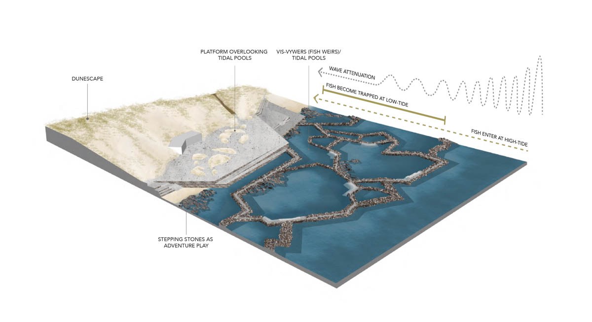
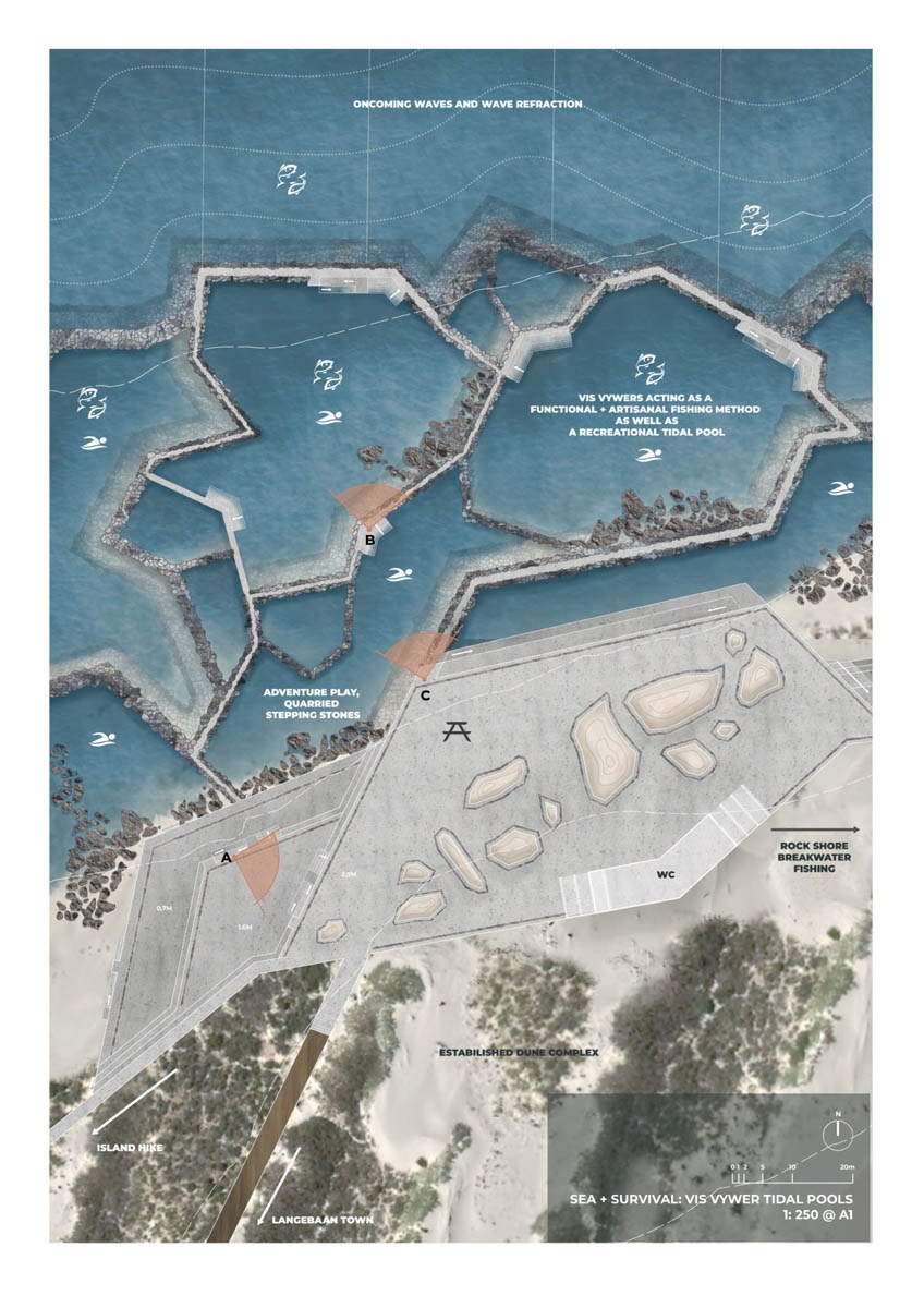
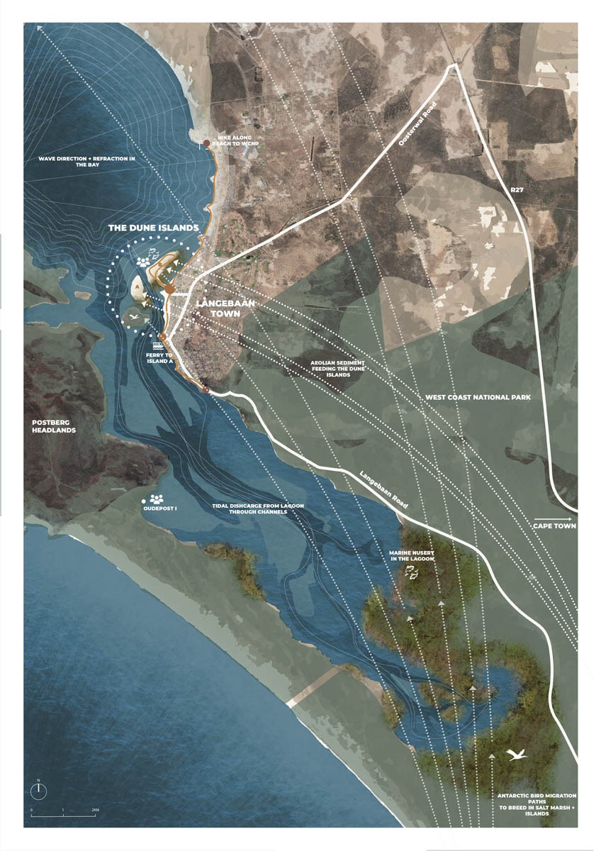
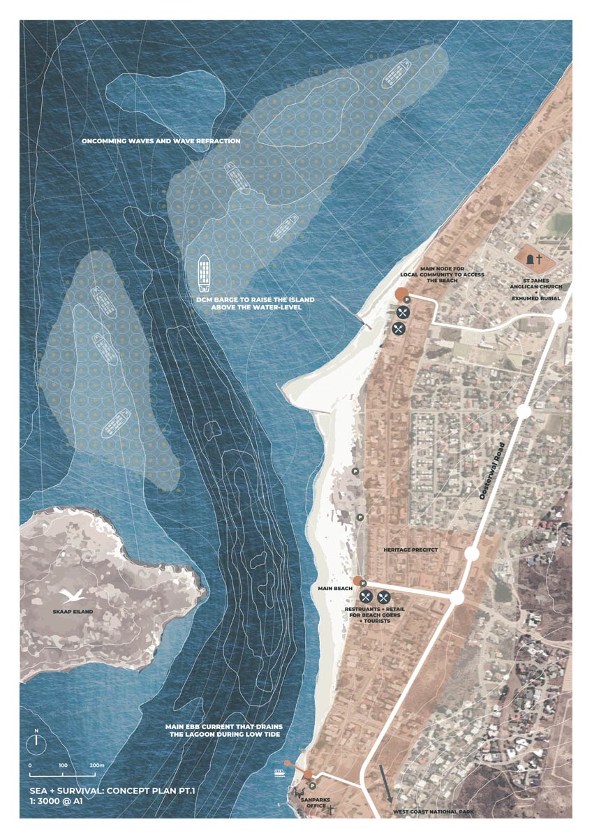
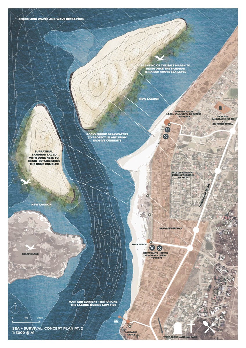
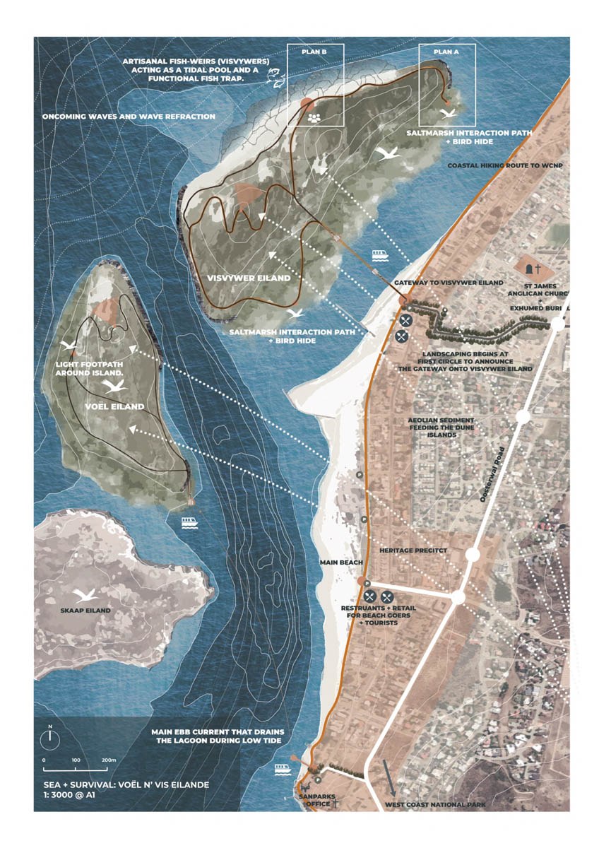
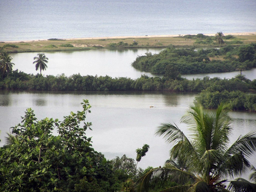
7. Sea + Survival: Choreographing Dune Systems
Abigail Victoria Sendall - Source: worldlandscapearchitect.com
Location: Langebaan Lagoon, Western Cape, South Africa
Designer: Abigail Victoria Sendall (University of Cape Town, Master of Landscape Architecture)
Type: Ecological Design / Climate Adaptation / Cultural Landscape Restoration
Website: University of Cape Town Thesis Repositoryopen.uct.ac.za
Overview
Sea + Survival: Choreographing Dune Systems is a master's thesis project by Abigail Victoria Sendall, developed at the University of Cape Town. The project addresses the pressing issue of sea-level rise and its impact on the coastal town of Langebaan, South Africa. Langebaan faces significant challenges due to poorly planned coastal development that has compromised natural dune systems and limited public access to the shoreline.
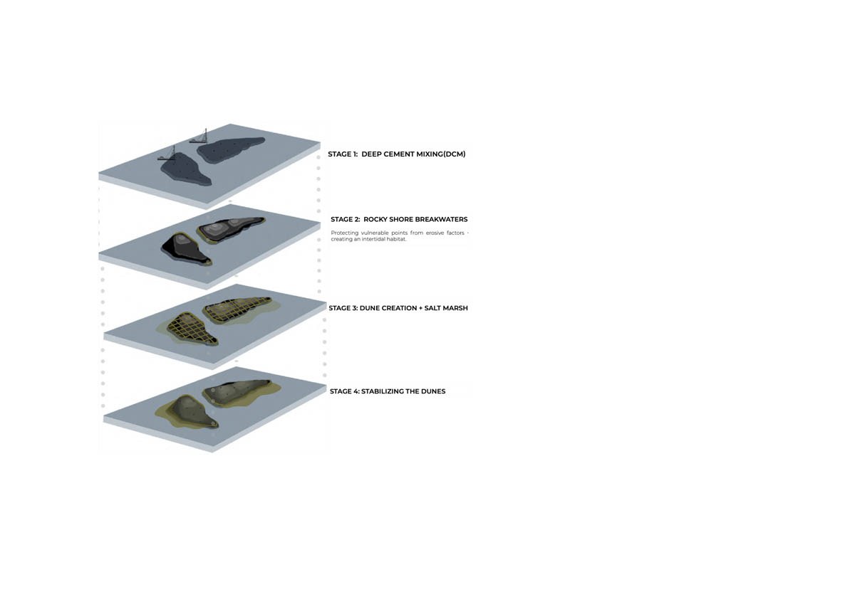
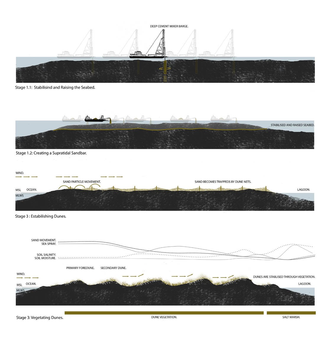
The design proposes the creation of two ecological islands within the Langebaan Lagoon. These islands aim to restore natural sediment dynamics, protect against coastal erosion, and reintroduce cultural practices, thereby enhancing both ecological resilience and community engagement.
Eco-Features
-
Ecological Islands: The proposed islands are formed by harnessing natural processes such as aeolian sediment transport and tidal forces. This approach is inspired by Ian McHarg's theory of naturally formed islands from sub-tidal sandbars.
-
Dune System Restoration: By creating offshore ecological islands, the project aims to alleviate pressure on existing dune systems, allowing them to recover and function effectively as natural coastal defences.
-
Tidal Interaction: The design incorporates features that interact dynamically with tidal movements, such as fish weirs that function as both marine food sources and tidal pools. worldlandscapearchitect.com
Ocean Conservation and Community Resilience Initiatives
-
Cultural Heritage Integration: The project acknowledges the historical significance of the area, including the displacement of indigenous Khoekhoe communities and the Cape Malay during apartheid. By reintroducing traditional practices like artisanal fish weirs, the design fosters cultural reconnection.
-
Public Space Enhancement: The creation of accessible platforms and play spaces encourages community interaction with the coastal environment, promoting environmental awareness and stewardship.
-
Educational Opportunities: The project serves as a living laboratory for ecological and cultural education, offering insights into sustainable coastal management practices.
Key Achievements
-
Innovative Design Approach: The project exemplifies a systems-based design methodology that integrates ecological processes with cultural narratives to address climate change challenges.
-
Restoration of Natural Processes: By facilitating the natural movement of sediments and tides, the design supports the regeneration of coastal ecosystems.
-
Community Empowerment: Through the inclusion of cultural elements and accessible spaces, the project empowers local communities to engage with and protect their coastal environment.
Role of Landscape Architecture
This project underscores the pivotal role of landscape architecture in addressing complex environmental and social issues. By choreographing natural systems and cultural practices, the design offers a holistic solution to coastal resilience, demonstrating how landscape architecture can facilitate ecological restoration, cultural reconnection, and community engagement in the face of climate change.
Learn More / References
-
University of Cape Town Thesis Repository: Sea + Survival: Choreographing Dune Systemsopen.uct.ac.za, open.uct.ac.za
-
World Landscape Architecture Feature: Student Project | SEA + SURVIVAL: Choreographing Dune Systems to Defend Against Climate Changelandscapearchitectureuct.com, worldlandscapearchitect.com
-
Landscape Architecture UCT: Abi Sendall
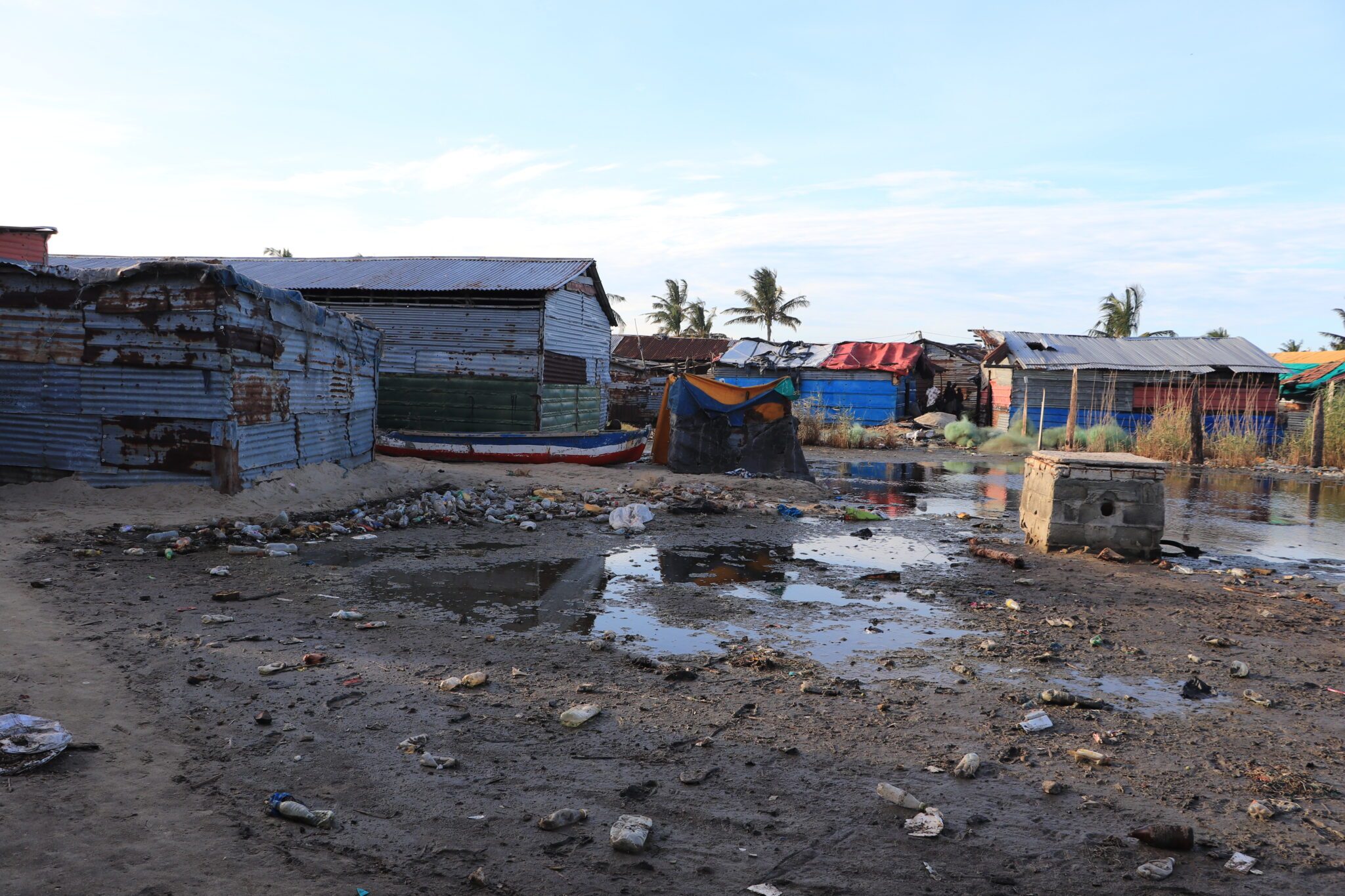
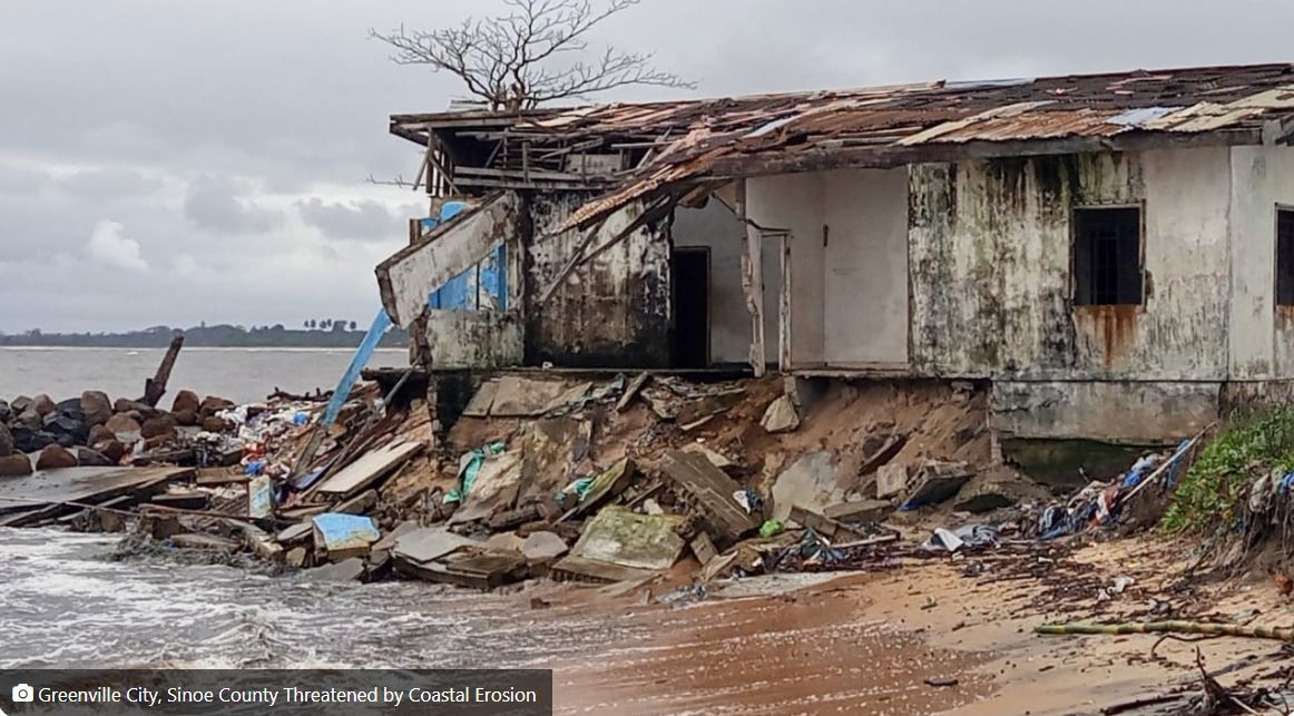
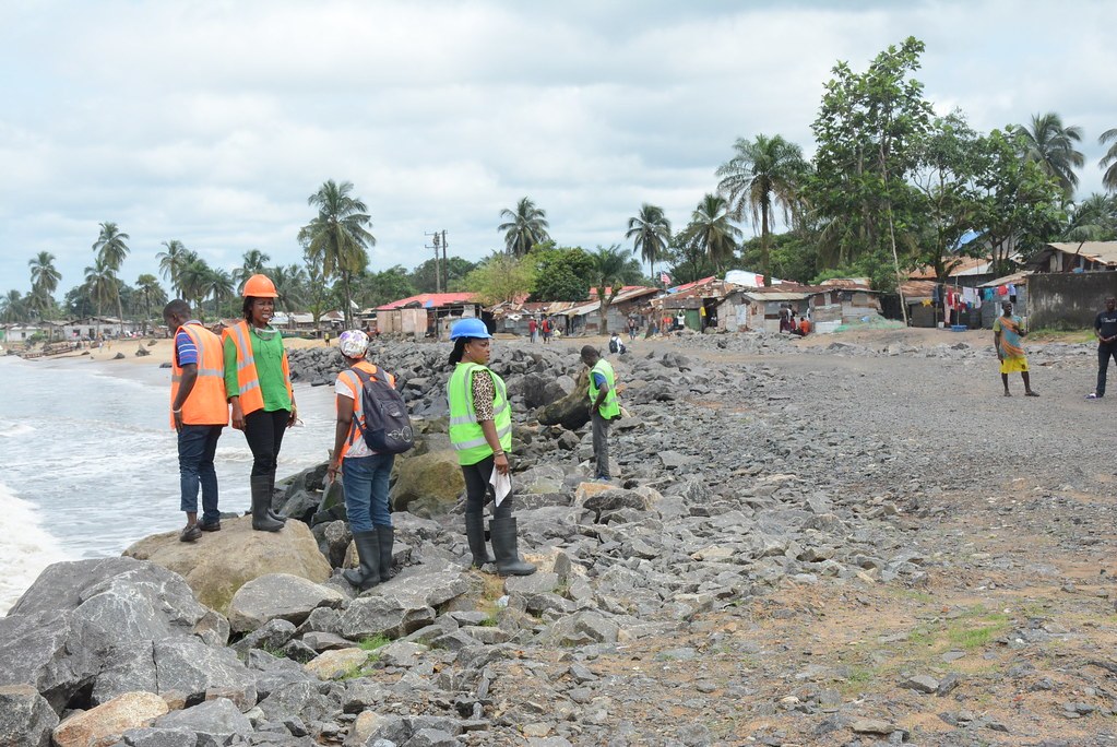
8. Enhancing the Resilience of Vulnerable Coastal Communities in Sinoe County, Liberia
Source: flickr.com
Source: wadr.org
Source: thenewdawnliberia.com
Location: Sinoe County, Liberia
Lead Organizations: United Nations Development Programme (UNDP), Government of Liberia
Type: Ecosystem-Based Adaptation / Coastal Habitat Restoration / Community Livelihoods
Website: adaptation-undp.org
Overview
This initiative aims to bolster the resilience of approximately 80,000 individuals in Liberia's coastal communities by restoring degraded coastal habitats and promoting sustainable livelihoods. The project focuses on rehabilitating 20,000 hectares of coastal ecosystems, including mangroves and wetlands, which serve as natural buffers against climate-induced hazards. By integrating ecosystem restoration with community development, the project seeks to enhance both environmental and socio-economic resilience.
Eco-Features
-
Coastal Ecosystem Restoration: Rehabilitation of mangroves, wetlands, and other critical habitats to mitigate coastal erosion and flooding.
-
Sustainable Resource Management: Promotion of eco-friendly practices in agriculture, fisheries, and forestry to ensure long-term ecosystem health.
-
Climate-Resilient Infrastructure: Construction of protective structures and improvement of drainage systems to reduce vulnerability to climate impacts.
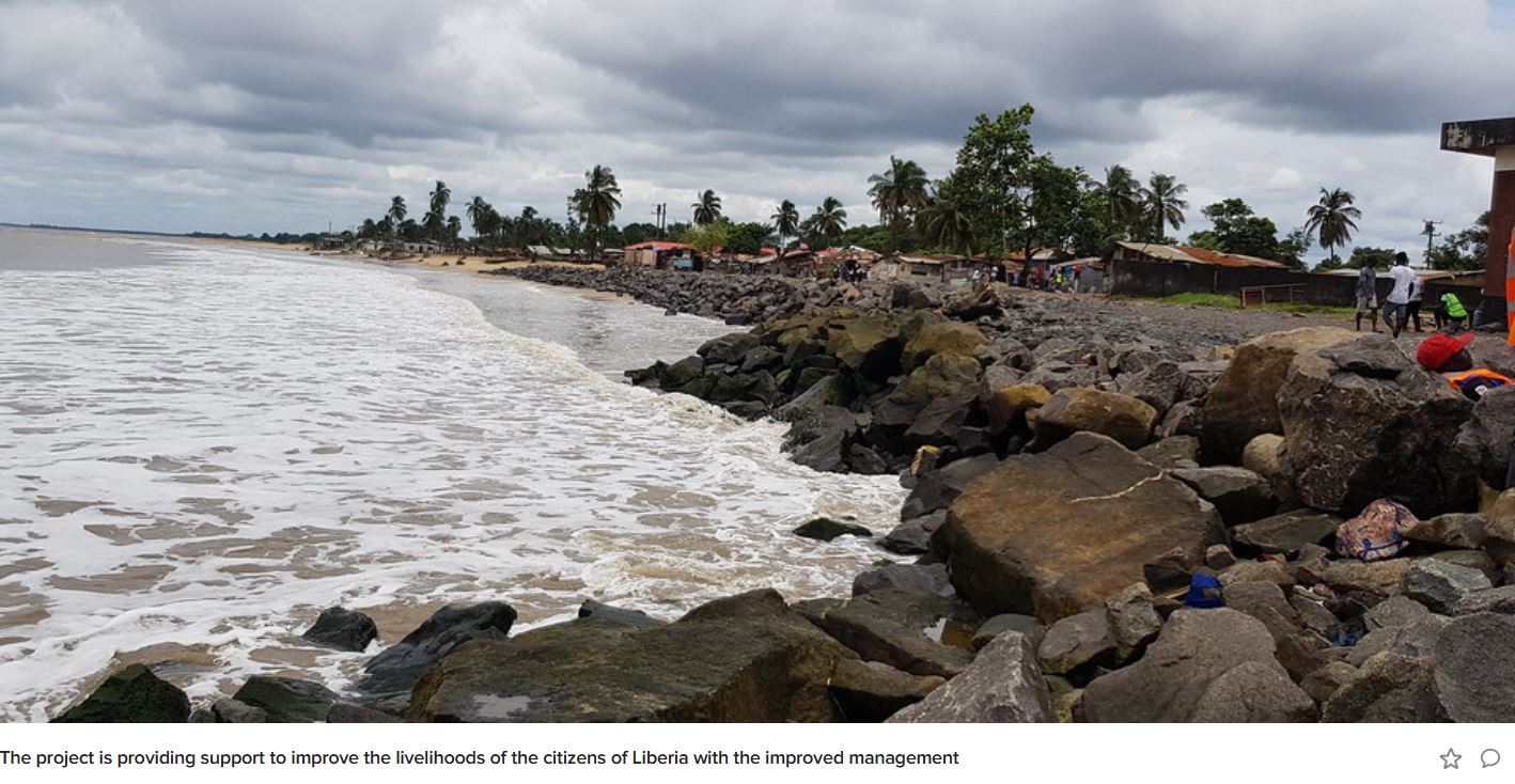
Building Coastal Defence Wall - Source: flickr.com
Ocean Conservation and Community Resilience Initiatives
-
Livelihood Diversification: Support for small, micro, and medium enterprises (SMMEs) in sectors like aquaculture and eco-tourism, with a focus on empowering women and youth.
-
Capacity Building: Training programs for local communities on sustainable practices and climate adaptation strategies.
-
Community Engagement: Involvement of local stakeholders in planning and decision-making processes to ensure the relevance and sustainability of interventions.
Key Achievements
-
Ecosystem Rehabilitation: Restoration of 20,000 hectares of coastal habitats, enhancing biodiversity and natural protection against climate hazards.
-
Economic Empowerment: Development of SMMEs benefiting 70,000 individuals, fostering economic resilience.
-
Food Security: Implementation of integrated farming systems and fisheries benefiting 30,000 people, improving nutrition and income.
Role of Landscape Architecture
While not led by traditional landscape architects, the project embodies core principles of the discipline, such as ecological restoration, sustainable land-use planning, and community-centered design. By integrating natural systems with human development, the initiative demonstrates how landscape architecture can contribute to climate adaptation and resilience in vulnerable coastal regions.
9. Buffelsdraai Landfill Site Community Reforestation Project – Durban, South Africa
Location: eThekwini Municipality, KwaZulu-Natal, South Africa
Lead Organizations: eThekwini Municipality, Wildlands Conservation Trust
Type: Ecosystem-Based Adaptation / Community Reforestation / Climate Mitigation
Website:
Overview
Initiated in 2008, the Buffelsdraai Community Reforestation Project aims to mitigate climate change impacts by restoring indigenous forest ecosystems around the Buffelsdraai Landfill Site. The project serves as a carbon offset initiative for events like the 2010 FIFA World Cup and COP17/CMP7, while also enhancing biodiversity and providing socio-economic benefits to local communities.
Eco-Features
-
Indigenous Reforestation: Planting over 500,000 native trees to restore 580 hectares of degraded land, enhancing carbon sequestration and biodiversity.
-
Ecosystem Services Enhancement: Improvement of water regulation, soil stability, and habitat connectivity through forest restoration.
-
Green Infrastructure: Development of a 'living fence' using thorny trees to protect the landfill site and surrounding communities.
Ocean Conservation and Community Resilience Initiatives
-
Community Empowerment: Engagement of local 'Tree-preneurs' who grow and trade indigenous seedlings for essential goods and services, fostering economic resilience.
-
Educational Opportunities: Establishment of a Centre of Excellence for climate change adaptation and restoration ecology, promoting environmental education.
-
Job Creation: Generation of employment opportunities in tree planting, invasive species control, and environmental management.
Key Achievements
-
Carbon Sequestration: Projected absorption of over 42,000 tons of CO₂ over 20 years, contributing to climate mitigation efforts.
-
Biodiversity Conservation: Restoration of critical habitats, supporting a range of flora and fauna species.
-
Socio-Economic Benefits: Creation of over 600 jobs and support for more than 600 active Tree-preneurs, enhancing community livelihoods.
Role of Landscape Architecture
The project exemplifies the role of landscape architecture in integrating ecological restoration with community development. By designing multifunctional landscapes that provide environmental, social, and economic benefits, the initiative showcases how landscape architecture can contribute to sustainable urban planning and climate resilience.
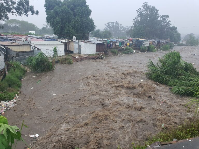
10. Masterplan Beira 2035 – Mozambique
Location: Beira, Mozambique
Lead Organizations: City of Beira, Witteveen+Bos (Dutch engineering consultancy)
Type: Integrated Urban Water Management / Climate Adaptation / Resilient Infrastructure
Website:
Overview
The Masterplan Beira 2035 is a comprehensive urban development strategy aimed at enhancing the city's resilience to climate change impacts, particularly flooding and sea-level rise. Developed in collaboration with Dutch engineering firm Witteveen+Bos, the plan focuses on overhauling water management infrastructure to support sustainable urban growth and improve the quality of life for residents.
Eco-Features
-
Stormwater Management: Construction of deeper drainage channels and a 150-hectare retention basin to manage stormwater and reduce flooding.
-
Coastal Defense: Reinforcement of natural and artificial coastal barriers through dredging and beach nourishment to combat erosion.
-
Wetland Restoration: Integration of wetlands into the urban landscape to enhance biodiversity and provide natural flood mitigation.
Ocean Conservation and Community Resilience Initiatives
-
Land-Use Planning: Implementation of zoning regulations to prevent development in high-risk flood zones, promoting safer and more sustainable urban expansion.
-
Community Engagement: Involvement of local stakeholders in planning processes to ensure that interventions meet community needs and priorities.
-
Economic Development: Enhancement of port infrastructure and tourism potential through improved water management and coastal protection.
Key Achievements
-
Infrastructure Improvement: Development of resilient water management systems that reduce flood risk and support urban growth.
-
Environmental Restoration: Rehabilitation of coastal and wetland ecosystems, contributing to biodiversity conservation and climate adaptation.
-
Disaster Recovery: Utilization of the masterplan as a framework for rebuilding and enhancing resilience following Cyclone Idai in 2019.
Role of Landscape Architecture
The Masterplan Beira 2035 highlights the importance of landscape architecture in designing adaptive urban environments. By integrating green infrastructure and ecological principles into urban planning, the project demonstrates how landscape architecture can address complex challenges related to climate change, urbanization, and community resilience.
.
Featured Posts
Blog Topics
Urban environment & Public spaces
Stay updated with the latest articles and insights from The Landscape Lab. Here, you will find valuable information and engaging content.
Waterfront & Coastal Resilience
Stay updated with the latest articles and insights from The Landscape Lab. Here, you will find valuable information and engaging content.
Captivating Photography
Stay updated with the latest articles and insights from The Landscape Lab. Here, you will find valuable information and engaging content.
Why Read The Landscape Lab Blog?
The way we design and interact with landscapes is more important than ever. As cities expand, coastlines shift, and climate change reshapes our world, the choices we make about land, water, and urban spaces have lasting impacts. The Landscape Lab Blog is here to spark fresh conversations, challenge conventional thinking, and inspire new approaches to sustainable and resilient design.
If you’re a landscape architect, urban planner, environmentalist, or simply someone who cares about how our surroundings shape our lives, this blog offers insights that matter. We explore the intersections between nature and the built environment, diving into real-world examples of cities adapting to rising sea levels, innovative waterfront designs, and the revival of native ecosystems. We look at how landscapes can work with nature rather than against it, ensuring long-term sustainability and biodiversity.
By reading The Landscape Lab, you'll gain a deeper understanding of the evolving field of landscape design—from rewilding initiatives to regenerative urban planning. Whether it’s uncovering the forgotten history of resilient landscapes, analyzing groundbreaking projects, or discussing the future of green infrastructure, this blog provides a space for learning, inspiration, and meaningful dialogue.
Location:
The Landscape Lab
123 Greenway Drive
Garden City
NY 12345
United Kingdom
Contact Number:
Get in Touch:
contact@thelandscapelab.co.uk
© 2025 thelandscapelab.co.uk - Your go-to blog for landscaping insights